1990s Maps of Shovel Lake, Minnesota
Explore 2 historic maps of Shovel Lake from the 1990s. These maps offer a rare glimpse into what life looked like during the 1990s — showing old roads, neighborhoods, homes, and landmarks that have changed or disappeared over time.
Whether you're researching your family's past, planning a metal detecting trip, or studying how Shovel Lake's landscape evolved across the 1990s, these high-resolution maps are a powerful tool for exploring the history of this region.
- Focus on a specific era: All maps on this page are from the 1990s, giving you a focused view of this time period.
- See what’s changed: Compare century-old streets, trails, and buildings to today's modern landscape using overlays and satellite layers.
- Research with precision: Use these maps for genealogy, historical research, land use analysis, or educational projects.
- View, download, or print: Maps are fully viewable online in high resolution, and can be downloaded or printed for your own records.
Start exploring Shovel Lake's history through authentic maps from the 1990s. This is your window into the past.
Shovel Lake, MN maps
(2)- 1994 Map of Aitkin
 1994 Aitkin1994 Print · USGSIn the mid-1990s, the lake country of central Minnesota remained a patchwork of state forests and rail-linked settlements. Researchers can trace the legacy of the Soo Line through towns like McGregor and Aitkin, or explore the vast reaches of the Savanna State Forest and Rice Lake.
 - 1996 Map of Shovel Lake, 1998 Print
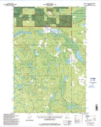 1996 Shovel Lake1998 Print · USGSCass and Aitkin Counties are shown in the mid-1990s as a densely forested landscape of state and national lands. Genealogists and local historians can locate the Townhall, Lakeview Cemetery, and the old settlement at Shovel Lake amidst the lakes and timber.
End of results
Showing maps 1-2 of 2
Top cities near Shovel Lake
- Emily historical maps
- Hill City historical maps
- Remer historical maps
- Waukenabo historical maps
- Little Pine historical maps
Frequently asked questions
- What are the different types of historical maps available for Shovel Lake?
- What is the oldest map of Shovel Lake?
- Where can I purchase historical maps of Shovel Lake for my home or office?
- Where can I download high-res historical maps of Shovel Lake?
- Are there historical topographic maps available for Shovel Lake?
- Is there historical aerial imagery available for Shovel Lake?
- Where are historical maps of Shovel Lake sourced from?