1910s Maps of Woodlyn Court, St. Francis
Explore 2 historic maps of Woodlyn Court from the 1910s. These maps offer a rare glimpse into what life looked like during the 1910s — showing old roads, neighborhoods, homes, and landmarks that have changed or disappeared over time.
Whether you're researching your family's past, planning a metal detecting trip, or studying how Woodlyn Court's landscape evolved across the 1910s, these high-resolution maps are a powerful tool for exploring the history of this region.
- Focus on a specific era: All maps on this page are from the 1910s, giving you a focused view of this time period.
- See what’s changed: Compare century-old streets, trails, and buildings to today's modern landscape using overlays and satellite layers.
- Research with precision: Use these maps for genealogy, historical research, land use analysis, or educational projects.
- View, download, or print: Maps are fully viewable online in high resolution, and can be downloaded or printed for your own records.
Start exploring Woodlyn Court's history through authentic maps from the 1910s. This is your window into the past.
Woodlyn Court, St. Francis maps
(2)- 1916 Map of St. Francis, 1960 Print
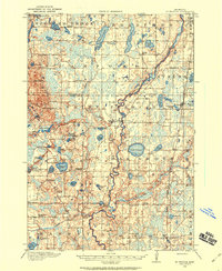 1916 St. Francis1960 Print · USGSAnoka and Isanti counties appear as a thriving network of rural townships and riverfront settlements just before the Great War. Genealogists can locate family-named landmarks and local hubs like Mitchell Corners, Nowthen, and the many numbered schoolhouses along the Rum River.3 unique versions available
 - 1919 Map of St. Francis
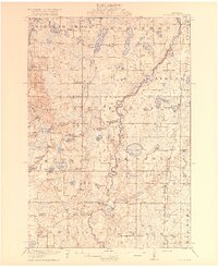 1919 St. Francis1919 Print · USGSAnoka and Isanti counties come alive in the decade following the Great War, showing a landscape defined by the winding Rum River. Genealogists can trace early homesteads and community hubs like Saint Francis, Mitchell Corners, and the Nowthen School.2 unique versions available
End of results
Showing maps 1-2 of 2
Top cities near Woodlyn Court
- Coon Rapids historical maps
- Blaine historical maps
- Andover historical maps
- Ramsey historical maps
- Champlin historical maps
- Elk River historical maps
See more
Frequently asked questions
- What are the different types of historical maps available for Woodlyn Court?
- What is the oldest map of Woodlyn Court?
- Where can I purchase historical maps of Woodlyn Court for my home or office?
- Where can I download high-res historical maps of Woodlyn Court?
- Are there historical topographic maps available for Woodlyn Court?
- Is there historical aerial imagery available for Woodlyn Court?
- Where are historical maps of Woodlyn Court sourced from?