1960s Maps of Bemidji, Minnesota
Explore 2 historic maps of Bemidji from the 1960s. These maps offer a rare glimpse into what life looked like during the 1960s — showing old roads, neighborhoods, homes, and landmarks that have changed or disappeared over time.
Whether you're researching your family's past, planning a metal detecting trip, or studying how Bemidji's landscape evolved across the 1960s, these high-resolution maps are a powerful tool for exploring the history of this region.
- Focus on a specific era: All maps on this page are from the 1960s, giving you a focused view of this time period.
- See what’s changed: Compare century-old streets, trails, and buildings to today's modern landscape using overlays and satellite layers.
- Research with precision: Use these maps for genealogy, historical research, land use analysis, or educational projects.
- View, download, or print: Maps are fully viewable online in high resolution, and can be downloaded or printed for your own records.
Start exploring Bemidji's history through authentic maps from the 1960s. This is your window into the past.
Bemidji, MN maps
(2)- 1968 Map of Bemidji East, 1970 Print
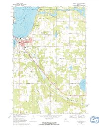 1968 Bemidji East1970 Print · USGSThe shorelines of the Mississippi headwaters in the late sixties show a landscape shaped by rail and water. Researchers can trace local genealogy and industry through Nymore, the Midway Seaplane Base, and the junction of the Great Soo and Northern Pacific lines.3 unique versions available
 - 1968 Map of Bemidji West, 1971 Print
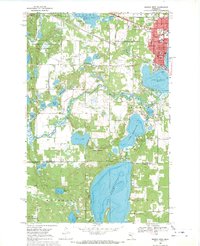 1968 Bemidji West1971 Print · USGSThe headwaters of the Mississippi intersect with a growing college town and rail hub in the late 1960s. Genealogists and historians can trace the campuses of Bemidji State College and Oak Hills Institute, or locate family plots at Greenwood Cem and Wilton Cem.2 unique versions available
End of results
Showing maps 1-2 of 2
Top cities near Bemidji
Top neighborhoods of Bemidji
- Hillcrest Manor historical maps
- Westwood Acres historical maps
- Skyline Village Mobile Home Park historical maps
Frequently asked questions
- What are the different types of historical maps available for Bemidji?
- What is the oldest map of Bemidji?
- Where can I purchase historical maps of Bemidji for my home or office?
- Where can I download high-res historical maps of Bemidji?
- Are there historical topographic maps available for Bemidji?
- Is there historical aerial imagery available for Bemidji?
- Where are historical maps of Bemidji sourced from?