Old Maps of Beltrami County, Minnesota
Explore 483 old maps of Beltrami County, spanning from 1918 to today. These high-resolution historic maps reveal how streets, neighborhoods, landmarks, and natural features evolved over time — perfect for genealogy, metal detecting, research, and local history exploration.
What you can do with these maps:
- See how Beltrami County changed over time: Compare historical maps to modern-day views to trace roads, homesites, rail lines & more.
- View detailed metadata: Each map includes creators, publishers, year, scale, and archive source.
- Overlay maps with satellite & LiDAR: Visualize the past alongside modern tools to explore terrain & human change.
- Trusted historical sources: Maps sourced from the USGS, Library of Congress, and other archives.
- Access maps your way: View online, download high-res files, or order prints for personal or research use.
Start exploring old maps of Beltrami County to uncover forgotten places, hidden landmarks, and the deep history beneath your feet.
Beltrami County, MN maps
(483)- 1918 Map of Winterroad
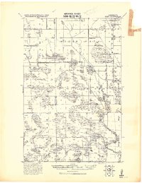
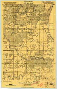
 1918 Winterroad1918 Print · USGSNorthern Minnesota’s drainage and timber frontiers are documented here just after the war, showing the massive engineering projects intended to dry the landscape. Local historians can trace the early township divisions of Eugene and Yale alongside landmarks like School 25 and Winter Road Lake.2 unique versions available
 - 1918 Map of F
 1918 F1918 Print · USGSBeltrami County’s northern wetlands are shown during a period of massive landscape engineering just after the Great War. Genealogists and historians can trace the early drainage infrastructure through the Main Judicial 1224 Ditch No 25 and find locations like Yale and Steenerson.
 - 1918 Map of Pencer
 1918 Pencer1918 Print · USGSNorthern Minnesota's borderlands appear in the late nineteen-teens as a landscape of timbered swamps and new drainage districts. Genealogists and local researchers can trace early rural life through scattered settlements like Pencer, Wannaska, and Casperson, or locate the Old Indian Reservation Boundary Line.
 - 1918 Map of Malcolm
 1918 Malcolm1918 Print · USGSBeltrami County was undergoing a massive hydrological transformation during the late teen years as drainage projects opened new lands for settlement. Genealogists and researchers can trace the early townships of Steenerson and Spruce Grove, locating rural hubs like Malcolm, Orheim, and the Town Hall at Carmel.
 - 1918 Map of Jelle
 1918 Jelle1918 Print · USGSNorthern Minnesota’s drainage projects and tribal lands are meticulously detailed in this survey from the late teens. Researchers can trace the early engineering of Main Judicial Ditch No 34 and locate the rural settlements of Jelle and Thorhult.
 - 1919 Map of Rosy
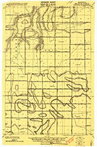
 1919 Rosy1919 Print · USGSNorthern Minnesota during the Great War era reveals a landscape of expanding infrastructure and reservation boundaries. Genealogists and researchers can trace local school locations and early settlements like Alvwood, Rosy, and Louis near the Third River.2 unique versions available
 - 1919 Map of G
 1919 G1919 Print · USGSBeltrami County at the end of the Great War reveals a landscape defined by massive drainage projects and the meandering South Branch Rapid River. Researchers can trace the early engineering of the peatlands via Jud. Ditch № 25 and locate specific timbered clearings labeled as Opening.
 - 1919 Map of Fox
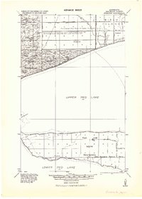
 1919 Fox1919 Print · USGSUpper Red Lake's eastern shoreline and the surrounding timbered wetlands are captured here during a period of massive drainage and reclamation. Genealogists and local historians can trace the early footprints of Waskish, Shotly, and Domaas, alongside the intricate network of Judicial Ditches that reshaped the land.
 - 1919 Map of Liner
 1919 Liner1919 Print · USGSNorthern Minnesota during the drainage era comes into focus on this 1919 survey, showing the extensive ditching projects designed to reclaim the marshlands. Researchers can trace early schools and settlements like Grygla, Randen, and Liner along the Moose River.
 - 1919 Map of Solway
 1919 Solway1919 Print · USGSNorthern Minnesota township life at the end of the Great War is captured here along the timbered ridges and lake basins of Beltrami County. Researchers can trace early railroad commerce through Solway and Pinewood, or locate rural landmarks like Bagley Dam and the Indian Reservation Boundary.
 - 1919 Map of Churnes
 1919 Churnes1919 Print · USGSNorthern Minnesota's timberlands and river valleys are captured here at the end of the Great War. Genealogists and researchers can trace early rural life through Berner, Churnes, and the Indian Farm, alongside the Red Lake Indian Reservation Boundary.
 - 1919 Map of Quiring
 1919 Quiring1919 Print · USGSNorthern Minnesota's timberlands and river basins are captured here during a transitional era of drainage and settlement. Genealogists and local historians can trace the early footprints of Saum, Quiring, and Langor, or locate landmarks like the Fork Church and the Old Indian Road.
 - 1919 Map of Norden
 1919 Norden1919 Print · USGSNorthern Minnesota’s drainage and timber frontier is captured here just after the Great War. Genealogists and researchers can trace the early township lines of Washkish and Norden alongside the historic Old Red Lake Indian Reservation Boundary.
 - 1919 Map of Ponemah
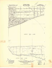 1919 Ponemah1919 Print · USGSThe northern lake country of Beltrami County is documented here at a time of significant landscape alteration within the Red Lake Indian Reservation. Researchers can trace early drainage projects like Jud. Ditch No. 25 and locate early settlements at Ponemah and Smithport.
 - 1919 Map of Knutson
 1919 Knutson1919 Print · USGSBeltrami County at the end of the Great War shows a landscape being actively reshaped by drainage projects and early surveying. Genealogists and historians can trace the development of the timbered wilderness through the routes of Rapid River and man-made systems like Judicial Ditch No 30 and Judicial Ditch No 36.
 - 1919 Map of Bridgie, 1924 Print
 1919 Bridgie1924 Print · USGSNorthern Minnesota timber country comes alive in this post-World War I era survey of the borderlands between Beltrami and Koochiching counties. Genealogists and historians can trace the early railroad boom through Northome, Funkley, and Orth along the Minnesota International line.
 - 1920 Map of Buena Vista, 1944 Print
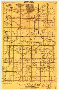
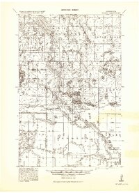
 1920 Buena Vista1944 Print · USGSBeltrami County at the opening of the 1920s reveals a landscape of timbered townships and lakeside outposts tied together by early rail and trail. Genealogists and researchers can locate old communities like Puposky, Lavinia, and Buena Vista, or trace the Indian Reservation Boundary and Turtle River Station.
 - 1924 Map of Bridgie, 1944 Print
 1924 Bridgie1944 Print · USGSNorthern Minnesota's woods and wetlands are captured here in the mid-1920s as the rail lines and early settlements began to formalize the landscape. Researchers can trace the path of the Minnesota International through vanished rail stops and small towns like Orth, Funkley, and Bridgie.
 - 1943 Map of Solway
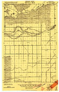
 1943 Solway1943 Print · USGSBeltrami County's timber and rail landscape is meticulously detailed here in the years following the first World War. Genealogists and researchers can trace family roots through rural stops like Solway, Aure, and Neving, or locate landmarks such as Bagley Dam and Pony Lake.
 - 1943 Map of Ponemah
 1943 Ponemah1943 Print · USGSThe Red Lake Indian Reservation is shown during the early 1940s, capturing the transition of the northern timberlands. Researchers can trace historic drainage networks like Jud. Ditch No. 82 and the lakefront settlements of Ponemah and Smithport.
 - 1954 Map of Bemidji, 1966 Print
 1954 Bemidji1966 Print · USGSNorthern Minnesota's lake country and timberlands are captured here at a mid-century peak of rail and road expansion. Genealogists and historians can trace family roots through numerous small settlements like Mahnomen, Clearbrook, and Walker, while locating local landmarks such as White Earth Church.4 unique versions available
 - 1954 Map of Roseau, 1969 Print
 1954 Roseau1969 Print · USGSNorthern Minnesota's borderlands come alive in the 1950s, showing a landscape defined by timber, water, and rail. Trace family roots through old schools and cemeteries near Roseau, Warroad, and the expansive Red Lake Indian Reservation.2 unique versions available
 - 1957 Map of Roseau
 1957 Roseau1957 Print · USGSThe international border and tribal lands define Northern Minnesota in the mid-fifties, from the shores of Lake of the Woods to the Red Lake Indian Reservation. Researchers can trace the path of the Great Northern railroad and locate isolated outposts like the U S Custom House and Ponemah.
 - 1957 Map of Bemidji
 1957 Bemidji1957 Print · USGSNorthern Minnesota in the mid-fifties is defined by its massive lake systems and the sprawling timberlands of the Chippewa National Forest. Genealogists and researchers can trace old rail lines like the Great Northern RR and locate settlements such as Moberg, Naytahwaush, and Lake Itasca.
 - 1958 Map of Bemidji
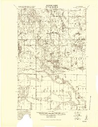
 1958 Bemidji1958 Print · USGSNorthern Minnesota in the late fifties is a vast landscape of tribal lands and timber forests tied together by rail. Genealogists and researchers can trace old rail stops and lakeside communities from Walker to Fosston, or explore the source of the Mississippi at Lake Itasca.
Showing maps 1-25 of 483
Top cities of Beltrami County
- Bemidji historical maps
- Blackduck historical maps
- Hines historical maps
- Nebish historical maps
- Kelliher historical maps
- Tenstrike historical maps
See more
Frequently asked questions
- What are the different types of historical maps available for Beltrami County?
- What is the oldest map of Beltrami County?
- Where can I purchase historical maps of Beltrami County for my home or office?
- Where can I download high-res historical maps of Beltrami County?
- Are there historical topographic maps available for Beltrami County?
- Is there historical aerial imagery available for Beltrami County?
- Where are historical maps of Beltrami County sourced from?