1960s Maps of Beltrami County, Minnesota
Explore 6 historic maps of Beltrami County from the 1960s. These maps offer a rare glimpse into what life looked like during the 1960s — showing old roads, neighborhoods, homes, and landmarks that have changed or disappeared over time.
Whether you're researching your family's past, planning a metal detecting trip, or studying how Beltrami County's landscape evolved across the 1960s, these high-resolution maps are a powerful tool for exploring the history of this region.
- Focus on a specific era: All maps on this page are from the 1960s, giving you a focused view of this time period.
- See what’s changed: Compare century-old streets, trails, and buildings to today's modern landscape using overlays and satellite layers.
- Research with precision: Use these maps for genealogy, historical research, land use analysis, or educational projects.
- View, download, or print: Maps are fully viewable online in high resolution, and can be downloaded or printed for your own records.
Start exploring Beltrami County's history through authentic maps from the 1960s. This is your window into the past.
Beltrami County, MN maps
(6)- 1968 Map of Bemidji East, 1970 Print
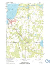 1968 Bemidji East1970 Print · USGSThe shorelines of the Mississippi headwaters in the late sixties show a landscape shaped by rail and water. Researchers can trace local genealogy and industry through Nymore, the Midway Seaplane Base, and the junction of the Great Soo and Northern Pacific lines.3 unique versions available
 - 1968 Map of Mulligan Lake SW, 1971 Print
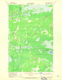
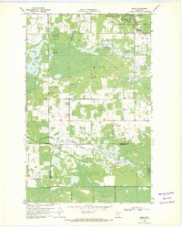
 1968 Mulligan Lake SW1971 Print · USGSNorthern Minnesota's wetland forests are captured here in the late sixties as the state park system and tribal lands defined the landscape. You can trace early settlement markers like the Elkwood Cem, the crossroads at Winner, and the shores of Hayes Lake.
 - 1968 Map of Bemidji West, 1971 Print
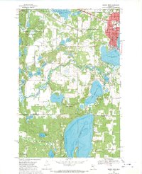 1968 Bemidji West1971 Print · USGSThe headwaters of the Mississippi intersect with a growing college town and rail hub in the late 1960s. Genealogists and historians can trace the campuses of Bemidji State College and Oak Hills Institute, or locate family plots at Greenwood Cem and Wilton Cem.2 unique versions available
 - 1968 Map of Mulligan Lake, 1971 Print
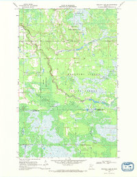
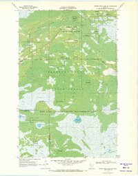
 1968 Mulligan Lake1971 Print · USGSNorthern Minnesota’s wilderness is mapped in the late sixties as it straddles the meeting point of Roseau, Beltrami, and Lake of the Woods counties. Trace the intricate network of Jeep Trails crossing the Red Lake Indian Reservation and the Beltrami Island State Forest.3 unique versions available
 - 1969 Map of Winter Road Lake SW, 1971 Print
 1969 Winter Road Lake SW1971 Print · USGSBeltrami and Lake of the Woods counties appear here in the late sixties as a vast landscape of conservation and reservation lands. Researchers can trace the O'Brien Trail or locate the Wildwood Cem and Norris Lookout Tower.2 unique versions available
 - 1969 Map of Skime, 1971 Print
 1969 Skime1971 Print · USGSNorthern Minnesota's borderlands come into focus in the late sixties as the wilderness of the Beltrami Island State Forest meets rural settlements. Genealogists and local historians can locate the Bethesda Ch, the Reine Cem, and the small community of Skime.
End of results
Showing maps 1-6 of 6
Top cities of Beltrami County
- Bemidji historical maps
- Blackduck historical maps
- Hines historical maps
- Nebish historical maps
- Kelliher historical maps
- Tenstrike historical maps
See more
Frequently asked questions
- What are the different types of historical maps available for Beltrami County?
- What is the oldest map of Beltrami County?
- Where can I purchase historical maps of Beltrami County for my home or office?
- Where can I download high-res historical maps of Beltrami County?
- Are there historical topographic maps available for Beltrami County?
- Is there historical aerial imagery available for Beltrami County?
- Where are historical maps of Beltrami County sourced from?