1970s Maps of Beltrami County, Minnesota
Explore 70 historic maps of Beltrami County from the 1970s. These maps offer a rare glimpse into what life looked like during the 1970s — showing old roads, neighborhoods, homes, and landmarks that have changed or disappeared over time.
Whether you're researching your family's past, planning a metal detecting trip, or studying how Beltrami County's landscape evolved across the 1970s, these high-resolution maps are a powerful tool for exploring the history of this region.
- Focus on a specific era: All maps on this page are from the 1970s, giving you a focused view of this time period.
- See what’s changed: Compare century-old streets, trails, and buildings to today's modern landscape using overlays and satellite layers.
- Research with precision: Use these maps for genealogy, historical research, land use analysis, or educational projects.
- View, download, or print: Maps are fully viewable online in high resolution, and can be downloaded or printed for your own records.
Start exploring Beltrami County's history through authentic maps from the 1970s. This is your window into the past.
Beltrami County, MN maps
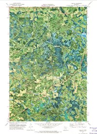
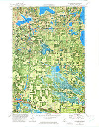
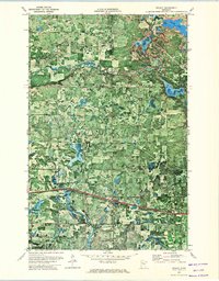
(70)- 1971 Map of Gimmer Lake, 1974 Print
 1971 Gimmer Lake1974 Print · USGSThe Beltrami and Itasca county line runs through this heavily forested lake country during the early seventies. Genealogists and historians can trace the Leech Lake Indian Reservation Boundary and locate landmarks like Kitchi Ch and Gimmer Lake.
 - 1971 Map of Funkley, 1974 Print
 1971 Funkley1974 Print · USGSNorthern Minnesota in the early seventies reveals a landscape of winding rivers and timbered townships along the county line. Genealogists and researchers can trace the rail corridor of the Burlington Northern and find local landmarks like St Joseph Ch and the settlement of Funkley.
 - 1971 Map of Decker Lake, 1974 Print
 1971 Decker Lake1974 Print · USGSBeltrami and Itasca counties appear as a dense wilderness of timber and wetlands in the early seventies. Researchers can trace the intricate waterways and forest boundaries near Decker Lake, Third River, and the Chippewa National Forest.
 - 1971 Map of Pennington, 1974 Print
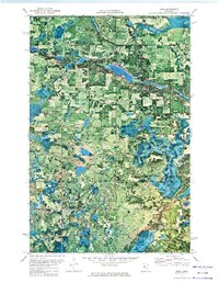
 1971 Pennington1974 Print · USGSNorthern Minnesota's lake country is captured in the early seventies, showing where the Mississippi River links the Chippewa National Forest and Buena Vista State Forest. Trace the shoreline development near Pennington or locate the Field Eagle Center and Castaway Camp.
 - 1971 Map of Kelliher, 1974 Print
 1971 Kelliher1974 Print · USGSNorthern Minnesota timber and bog country come into focus in the early seventies, centered on the village of Kelliher. Researchers can trace the local landscape through landmarks like St Joseph Ch, the Kelliher Cem, and the old Winter Trail.
 - 1972 Map of Bagley Lake, 1974 Print
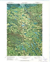
 1972 Bagley Lake1974 Print · USGSThe northern lake country of Beltrami County is documented here in the early 1970s, showcasing the intersection of tribal lands and state conservation areas. Researchers can locate community anchors like Faith Chapel, the Big Meadows Lookout Tower, and the lakeside settlement of Balm.
 - 1972 Map of Alida, 1974 Print
 1972 Alida1974 Print · USGSNorthern Minnesota's glacial lake country is frozen in time during the early seventies, capturing the headwaters region as it transitioned into the modern era. Genealogists and local historians can locate the Alida settlement, the Township Cem, and the winding course of the Little Mississippi River.
 - 1972 Map of Blackduck, 1974 Print
 1972 Blackduck1974 Print · USGSThe Northwoods of Beltrami County are documented here in the early seventies as a dense network of timberlands and glacial lakes. Local researchers can pinpoint the Township Cem, the historic Camp Rabideau, and the industrial path of the Burlington Northern railroad.
 - 1972 Map of Peterson Lake, 1974 Print
 1972 Peterson Lake1974 Print · USGSNorth of Bemidji in the early 1970s, the landscape was a mix of dense forest, treaty lands, and growing infrastructure. Genealogists can locate family landmarks like Werner, the Northern Cem, and the quiet Chapel in the Pines.2 unique versions available
 - 1972 Map of Turtle River Lake, 1974 Print
 1972 Turtle River Lake1974 Print · USGSNorthern Minnesota's lake country is captured here in the early seventies as the timber and rail industries shaped Beltrami County. Genealogists and historians can trace the Burlington Northern line and locate local landmarks like the Townhall and Turtle River settlement.
 - 1972 Map of Saum NE, 1974 Print
 1972 Saum NE1974 Print · USGSNorthern Minnesota’s timbered wetlands and reservation borders are captured here during the early seventies. Genealogists and historians can trace the Old Indian Treaty Boundary as it cuts past Battle River and Red Lake State Forest.
 - 1972 Map of Pimushe Lake, 1974 Print
 1972 Pimushe Lake1974 Print · USGSBeltrami County’s lake-strewn timberlands are captured in the early seventies, showing a landscape defined by state forests and tribal boundaries. Researchers can locate the Township Cem and Townhall or trace the shores of Pimushe Lake and Big Lake.2 unique versions available
 - 1972 Map of Redby, 1974 Print
 1972 Redby1974 Print · USGSRedby and the surrounding reservation lands are captured in the early seventies through this detailed orthophotomap. Genealogists and historians can trace the lakeside development of Redby and the scattered waters of Rice Lake, Lake Shemahgun, and Nebish Lake.
 - 1972 Map of White Fish Lake, 1974 Print
 1972 White Fish Lake1974 Print · USGSThe woods of northern Minnesota come into sharp focus in the early 1970s, showing a dense landscape of interconnected lakes and state forest land. Genealogists and researchers can trace the shorelines of White Fish Lake, Turtle Lake, and the early layout of Three Island Lake County Park.
 - 1972 Map of Debs, 1974 Print
 1972 Debs1974 Print · USGSThe lake country of Beltrami County is revealed in the early 1970s through this detailed orthophotomap showing the woods and wetlands at a 1:24,000 scale. Researchers can locate the Sinclair Cem, the Soo Line tracks, and the small settlement of Debs.
 - 1972 Map of O'Brien Lookout Tower, 1974 Print
 1972 O'Brien Lookout Tower1974 Print · USGSBeltrami County in the early seventies is captured in this unique aerial-photographic survey of the northern Minnesota wetlands. Researchers can locate the Caldwell Cem, the O'Brien Lookout Tower, and the winding path of the South Cormorant River.
 - 1972 Map of Red Lake, 1974 Print
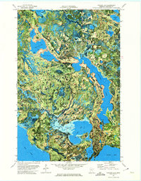
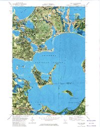
 1972 Red Lake1974 Print · USGSThe Red Lake Indian Reservation shoreline is captured here in the early seventies, showing the northern settlement and its surrounding wetlands. Researchers can trace local landmarks like Red Lake, Dell Chapel, and Island Lake Cem among dozens of interior lakes.
 - 1972 Map of Solway, 1974 Print
 1972 Solway1974 Print · USGSBeltrami and Clearwater counties appear in the early 1970s as timber and transit corridors define the rural landscape. Genealogists and local historians can trace family locations near Solway Cem or follow the Old Indian Treaty Boundary and the Old Railroad Grade.
 - 1972 Map of Grant Lake, 1974 Print
 1972 Grant Lake1974 Print · USGSUpper Mississippi River headwaters and northern timberlands are captured here in the early 1970s, showing the early reach of the great river. Researchers can trace the boundaries of the Mississippi Headwaters State Forest and locate specific sites like Roglien Memorial Park and the Lookout Tower.
 - 1972 Map of Borden Lake, 1974 Print
 1972 Borden Lake1974 Print · USGSBeltrami County in the early seventies shows a landscape defined by its timbered wetlands and winding waterways. Genealogists and researchers can trace the rural layouts of Inez and Langor, and find local landmarks like Cormorant Ch and Township Cem.
 - 1972 Map of Turtle River, 1974 Print
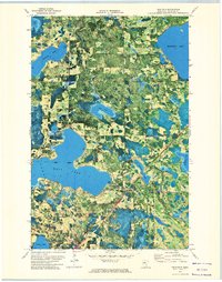
 1972 Turtle River1974 Print · USGSThe glacial lakes and forests of Beltrami County are captured in the early 1970s, showing the area's development as a recreation and timber hub. Researchers can locate family landmarks like Pine Ridge Cem, the Christenson Landing Field, and lakefront settlements at Birchmont and Lavinia.3 unique versions available
 - 1972 Map of Nebish, 1974 Print
 1972 Nebish1974 Print · USGSBeltrami County in the early seventies is captured here at the junction of state forest and tribal lands. Researchers can trace the boundaries of the Red Lake Indian Reservation and locate features like the settlement of Nebish and the shores of Dark Lake.
 - 1972 Map of Aure, 1974 Print
 1972 Aure1974 Print · USGSIn the early 1970s, this area of Beltrami County was a landscape of deep woods and glacial waters bordering the Red Lake Ind Res. Genealogists and local historians can locate the Buzzel Ch and trace the shores of Sandy Lake and Deer Lake.
 - 1972 Map of Tenstrike, 1974 Print
 1972 Tenstrike1974 Print · USGSBeltrami County’s lake-dotted timberlands are captured here in the early seventies, centered on the historic railroad village of Tenstrike. Genealogists and local historians can trace the tracks of the Burlington Northern, the Hope church, and the shores of Gull Lake.
 - 1972 Map of Cass Lake, 1974 Print
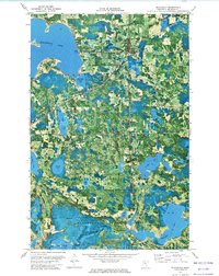
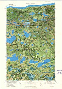
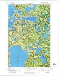
 1972 Cass Lake1974 Print · USGSThe northern woods and waters of the Leech Lake Indian Reservation are captured in the early 1970s. Trace the Burlington Northern Line through the town of CASS LAKE or locate family sites near Pine Grove Cem and SUGAR BUSH LAKE.
Showing maps 1-25 of 70
Top cities of Beltrami County
- Bemidji historical maps
- Blackduck historical maps
- Hines historical maps
- Nebish historical maps
- Kelliher historical maps
- Tenstrike historical maps
See more
Frequently asked questions
- What are the different types of historical maps available for Beltrami County?
- What is the oldest map of Beltrami County?
- Where can I purchase historical maps of Beltrami County for my home or office?
- Where can I download high-res historical maps of Beltrami County?
- Are there historical topographic maps available for Beltrami County?
- Is there historical aerial imagery available for Beltrami County?
- Where are historical maps of Beltrami County sourced from?