1940s Maps of Beltrami County, Minnesota
Explore 2 historic maps of Beltrami County from the 1940s. These maps offer a rare glimpse into what life looked like during the 1940s — showing old roads, neighborhoods, homes, and landmarks that have changed or disappeared over time.
Whether you're researching your family's past, planning a metal detecting trip, or studying how Beltrami County's landscape evolved across the 1940s, these high-resolution maps are a powerful tool for exploring the history of this region.
- Focus on a specific era: All maps on this page are from the 1940s, giving you a focused view of this time period.
- See what’s changed: Compare century-old streets, trails, and buildings to today's modern landscape using overlays and satellite layers.
- Research with precision: Use these maps for genealogy, historical research, land use analysis, or educational projects.
- View, download, or print: Maps are fully viewable online in high resolution, and can be downloaded or printed for your own records.
Start exploring Beltrami County's history through authentic maps from the 1940s. This is your window into the past.
Beltrami County, MN maps
(2)- 1943 Map of Solway
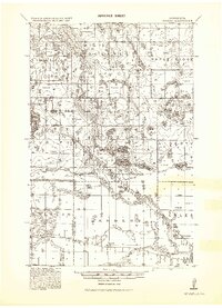 1943 Solway1943 Print · USGSBeltrami County's timber and rail landscape is meticulously detailed here in the years following the first World War. Genealogists and researchers can trace family roots through rural stops like Solway, Aure, and Neving, or locate landmarks such as Bagley Dam and Pony Lake.
 - 1943 Map of Ponemah
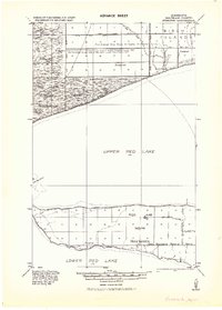 1943 Ponemah1943 Print · USGSThe Red Lake Indian Reservation is shown during the early 1940s, capturing the transition of the northern timberlands. Researchers can trace historic drainage networks like Jud. Ditch No. 82 and the lakefront settlements of Ponemah and Smithport.
End of results
Showing maps 1-2 of 2
Top cities of Beltrami County
- Bemidji historical maps
- Blackduck historical maps
- Hines historical maps
- Nebish historical maps
- Kelliher historical maps
- Tenstrike historical maps
See more
Frequently asked questions
- What are the different types of historical maps available for Beltrami County?
- What is the oldest map of Beltrami County?
- Where can I purchase historical maps of Beltrami County for my home or office?
- Where can I download high-res historical maps of Beltrami County?
- Are there historical topographic maps available for Beltrami County?
- Is there historical aerial imagery available for Beltrami County?
- Where are historical maps of Beltrami County sourced from?