2020s Maps of Wilton, Minnesota
Explore 4 historic maps of Wilton from the 2020s. These maps offer a rare glimpse into what life looked like during the 2020s — showing old roads, neighborhoods, homes, and landmarks that have changed or disappeared over time.
Whether you're researching your family's past, planning a metal detecting trip, or studying how Wilton's landscape evolved across the 2020s, these high-resolution maps are a powerful tool for exploring the history of this region.
- Focus on a specific era: All maps on this page are from the 2020s, giving you a focused view of this time period.
- See what’s changed: Compare century-old streets, trails, and buildings to today's modern landscape using overlays and satellite layers.
- Research with precision: Use these maps for genealogy, historical research, land use analysis, or educational projects.
- View, download, or print: Maps are fully viewable online in high resolution, and can be downloaded or printed for your own records.
Start exploring Wilton's history through authentic maps from the 2020s. This is your window into the past.
Wilton, MN maps
(4)- 2022 Map of Grant Lake, 2022 Print
 2022 Grant Lake2022 Print · USGSWilton and the lake-strewn northern Minnesota woods are captured here during the 2020s. Genealogists and local researchers can trace family land along Co Hwy 16 and locate properties near Grant Lake, Rice Lake, and the winding Little Mississippi River.
 - 2022 Map of Wilton, 2022 Print
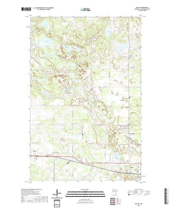 2022 Wilton2022 Print · USGSBeltrami County's wetland and lake country is captured here in the early twenty-first century, centered on the historic settlements of Wilton and Solway. Researchers can trace local heritage through numerous burial sites like Pinewood Cem and Lammers Cem among the many lakes.
 - 2022 Map of Peterson Lake, 2022 Print
 2022 Peterson Lake2022 Print · USGSBeltrami County's glacial lake country is captured here during the 2020s, showing the rural communities and infrastructure north of the city. Genealogists and local historians can trace family-named roads near Werner or locate sites like the Northern Cem and Bemidji Regional Airport.
 - 2022 Map of Bemidji West, 2022 Print
 2022 Bemidji West2022 Print · USGSThe headwaters of the Mississippi River wind through this lake-rich region west of Bemidji in the early 2020s. Genealogists and local historians can trace family plots at Wilton Cem or explore the surroundings of Lake Plantagenet and Oak Hills Christian College.
End of results
Showing maps 1-4 of 4
Top cities near Wilton
Frequently asked questions
- What are the different types of historical maps available for Wilton?
- What is the oldest map of Wilton?
- Where can I purchase historical maps of Wilton for my home or office?
- Where can I download high-res historical maps of Wilton?
- Are there historical topographic maps available for Wilton?
- Is there historical aerial imagery available for Wilton?
- Where are historical maps of Wilton sourced from?