1990s Maps of Federal Dam, Minnesota
Explore 3 historic maps of Federal Dam from the 1990s. These maps offer a rare glimpse into what life looked like during the 1990s — showing old roads, neighborhoods, homes, and landmarks that have changed or disappeared over time.
Whether you're researching your family's past, planning a metal detecting trip, or studying how Federal Dam's landscape evolved across the 1990s, these high-resolution maps are a powerful tool for exploring the history of this region.
- Focus on a specific era: All maps on this page are from the 1990s, giving you a focused view of this time period.
- See what’s changed: Compare century-old streets, trails, and buildings to today's modern landscape using overlays and satellite layers.
- Research with precision: Use these maps for genealogy, historical research, land use analysis, or educational projects.
- View, download, or print: Maps are fully viewable online in high resolution, and can be downloaded or printed for your own records.
Start exploring Federal Dam's history through authentic maps from the 1990s. This is your window into the past.
Federal Dam, MN maps
(3)- 1996 Map of Portage Lake, 1998 Print
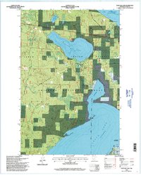 1996 Portage Lake1998 Print · USGSThe Cass County shoreline and forest interiors are captured here in the mid-1990s, where public lands and tribal territories intersect. Researchers can trace historical settlement at Ryan Village, locate family roots at Rabbits Cemetery, and study the landscape around Federal Dam.
 - 1996 Map of Sugar Point, 1998 Print
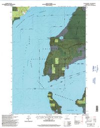 1996 Sugar Point1998 Print · USGSNorthern Minnesota's lake country is captured here in the mid-1990s, where the reservation meets the national forest along the shores of Leech Lake. Local historians can trace the site of the Battleground and locate the White Cloud Cemetery.2 unique versions available
 - 1996 Map of Federal Dam, 1998 Print
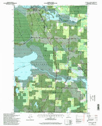 1996 Federal Dam1998 Print · USGSThe Cass County lake country comes into focus in the mid-1990s, where water and forest management define the landscape. Researchers can locate the Island Lake Cemetery, the site of the Sugar Point Battleground, and the hydrologic works at Federal Dam.
End of results
Showing maps 1-3 of 3
Top cities near Federal Dam
Frequently asked questions
- What are the different types of historical maps available for Federal Dam?
- What is the oldest map of Federal Dam?
- Where can I purchase historical maps of Federal Dam for my home or office?
- Where can I download high-res historical maps of Federal Dam?
- Are there historical topographic maps available for Federal Dam?
- Is there historical aerial imagery available for Federal Dam?
- Where are historical maps of Federal Dam sourced from?