1960s Maps of Glyndon, Minnesota
Explore 2 historic maps of Glyndon from the 1960s. These maps offer a rare glimpse into what life looked like during the 1960s — showing old roads, neighborhoods, homes, and landmarks that have changed or disappeared over time.
Whether you're researching your family's past, planning a metal detecting trip, or studying how Glyndon's landscape evolved across the 1960s, these high-resolution maps are a powerful tool for exploring the history of this region.
- Focus on a specific era: All maps on this page are from the 1960s, giving you a focused view of this time period.
- See what’s changed: Compare century-old streets, trails, and buildings to today's modern landscape using overlays and satellite layers.
- Research with precision: Use these maps for genealogy, historical research, land use analysis, or educational projects.
- View, download, or print: Maps are fully viewable online in high resolution, and can be downloaded or printed for your own records.
Start exploring Glyndon's history through authentic maps from the 1960s. This is your window into the past.
Glyndon, MN maps
(2)- 1964 Map of Glyndon South, 1966 Print
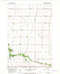
 1964 Glyndon South1966 Print · USGSClay County's agricultural heartland is documented here in the mid-1960s, centered on the vital rail junction at Glyndon. Researchers can trace local heritage through the locations of the Elmwood Cem, Trinity Ch, and the many sections of the Great Northern railroad.
 - 1964 Map of Glyndon North, 1966 Print
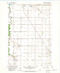
 1964 Glyndon North1966 Print · USGSClay County's agricultural landscape is seen here in the mid-sixties, dominated by the precision of the Red River Valley's drainage grid. Researchers can trace family roots near Glyndon at Riverside Cem or follow the Great Northern rail line through Averill.2 unique versions available
End of results
Showing maps 1-2 of 2
Top cities near Glyndon
- Fargo historical maps
- Moorhead historical maps
- Dilworth historical maps
- Barnesville historical maps
- Sabin historical maps
- Kragnes historical maps
See more
Frequently asked questions
- What are the different types of historical maps available for Glyndon?
- What is the oldest map of Glyndon?
- Where can I purchase historical maps of Glyndon for my home or office?
- Where can I download high-res historical maps of Glyndon?
- Are there historical topographic maps available for Glyndon?
- Is there historical aerial imagery available for Glyndon?
- Where are historical maps of Glyndon sourced from?