2020s Maps of East Cook, Minnesota
Explore 18 historic maps of East Cook from the 2020s. These maps offer a rare glimpse into what life looked like during the 2020s — showing old roads, neighborhoods, homes, and landmarks that have changed or disappeared over time.
Whether you're researching your family's past, planning a metal detecting trip, or studying how East Cook's landscape evolved across the 2020s, these high-resolution maps are a powerful tool for exploring the history of this region.
- Focus on a specific era: All maps on this page are from the 2020s, giving you a focused view of this time period.
- See what’s changed: Compare century-old streets, trails, and buildings to today's modern landscape using overlays and satellite layers.
- Research with precision: Use these maps for genealogy, historical research, land use analysis, or educational projects.
- View, download, or print: Maps are fully viewable online in high resolution, and can be downloaded or printed for your own records.
Start exploring East Cook's history through authentic maps from the 2020s. This is your window into the past.
East Cook, MN maps
(18)- 2022 Map of Mineral Center OE S, 2022 Print
 2022 Mineral Center OE S2022 Print · USGSThe open waters of the North Shore are the primary focus here during the early 2020s. Researchers and boaters can trace the path of the Lake Superior Water Trail as it skims the northern edge of Lake Superior.
 - 2022 Map of Hovland, 2022 Print
 2022 Hovland2022 Print · USGSMinnesota's North Shore is captured here in recent years, showing the quiet settlement of Hovland against the expanse of Lake Superior. Researchers can locate family landmarks like the Old Settlers Cem or trace the winding course of the Flute Reed River.
 - 2022 Map of Farquhar Peak, 2022 Print
 2022 Farquhar Peak2022 Print · USGSThe international border meets the deep Northwoods of Cook County in this recent survey. Outdoor enthusiasts and researchers can trace the Superior Hiking Trl past Farquhar Peak or follow the remote Swamp River through the heart of the Superior National Forest.
 - 2022 Map of Northern Light Lake, 2022 Print
 2022 Northern Light Lake2022 Print · USGSCook County's wilderness is captured here in the early twenty-first century, showcasing the deep woods and glacial waters of the Superior National Forest. Researchers can trace the path of the Gunflint to Grand Portage Trl and remote forest routes like Tofte Cabin Trl near Greenwood Lake.
 - 2022 Map of South Fowl Lake, 2022 Print
 2022 South Fowl Lake2022 Print · USGSNortheastern Minnesota's wilderness along the Canadian border is documented here in the early 2020s. Researchers can trace the international boundary line along the Pigeon River or follow the path of the Border Route Trl through Superior National Forest.
 - 2022 Map of Pine Lake East, 2022 Print
 2022 Pine Lake East2022 Print · USGSThe wilderness of Cook County and the Canadian border are captured in this recent survey of the North Woods. Outdoorsmen and historians can trace the Border Route Trl and Arrowhead Trl near remote outposts like the McFarland Ranger S.
 - 2022 Map of Gunflint Lake, 2022 Print
 2022 Gunflint Lake2022 Print · USGSThe northern border of the Superior National Forest is captured here at the international boundary. You can trace historic portage and wilderness routes like the Banadad Trl, the Border Route Trl, and the legendary Gunflint Trail.
 - 2022 Map of Long Island Lake, 2022 Print
 2022 Long Island Lake2022 Print · USGSThe remote wilderness of Cook County is mapped here during the early twenty-first century as it borders Ontario. Researchers can trace historic portage routes and backcountry paths like the Kekekabic Trl, Magnetic Rock Trl, and Border Route Trl through the Superior National Forest.
 - 2022 Map of South Lake, 2022 Print
 2022 South Lake2022 Print · USGSThe Boundary Waters wilderness along the Canadian border is captured here in the early twenty-first century. Outdoor historians and genealogists can trace the primitive Old Gunflint Road and traditional sites like Moozoogitagaaning Island.
 - 2022 Map of Kadunce River, 2022 Print
 2022 Kadunce River2022 Print · USGSThe North Shore of Minnesota is captured here in the early twenty-first century, showing the dense woods and rocky coast of Cook County. Researchers can trace forest access via Colvill Road or locate campsites and trails near Kimball Lake and the Kadunce River.
 - 2022 Map of Pine Mountain, 2022 Print
 2022 Pine Mountain2022 Print · USGSSuperior National Forest dominates this northern wilderness just after the turn of the twenty-first century, showing a landscape defined by its rivers and timber access. Trace the historic Gunflint Trail and find remote water bodies like Muckwa Lake and Northern Light Lake.
 - 2022 Map of Mineral Center, 2022 Print
 2022 Mineral Center2022 Print · USGSCoastal Cook County is shown here along the international border with Canada in the early 2020s. Researchers can locate the Mineral Center Cem and trace old routes like the Grand Portage Trl and Old Hwy 61 through the forest.
 - 2022 Map of Crocodile Lake, 2022 Print
 2022 Crocodile Lake2022 Print · USGSSuperior National Forest at the Canadian border comes into focus in this recent survey. Hikers and historians can trace the Border Route Trail and the historic Gunflint Trail, or locate the Old Logging Camp Trail and namesake Crocodile Lake.
 - 2022 Map of Pine Lake West, 2022 Print
 2022 Pine Lake West2022 Print · USGSThe Boundary Waters region of Cook County appears here as a labyrinth of glacial lakes and portage trails in the early twenty-first century. Outdoor historians and researchers can trace the Border Route Trl past landmarks like Moose Mtn and Pine Lake.
 - 2022 Map of Grand Marais, 2022 Print
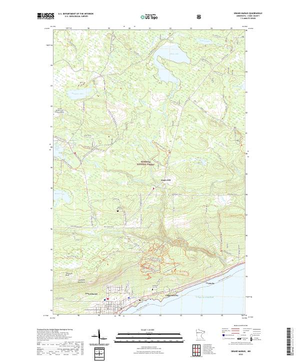 2022 Grand Marais2022 Print · USGSThe Lake Superior shoreline at the north woods edge comes into focus in this recent survey of the Cook County coast. Genealogists and hikers can trace sites like Chippewa City Cem, the historic Gunflint Trail, and the harbor at Grand Marais.
 - 2022 Map of Hungry Jack Lake, 2022 Print
 2022 Hungry Jack Lake2022 Print · USGSThe international boundary at Rose Lake marks this remote section of the Northwoods in the early twenty-first century. Outdoor historians can trace old timber routes like the Cgt-Old Logging Camp Trail Mai Trl and the famous Border Route Trl.
 - 2022 Map of Tom Lake, 2022 Print
 2022 Tom Lake2022 Print · USGSCook County's deep woods and glacial waters are captured here in the contemporary era. Researchers can trace remote forest access routes and recreational paths like the Superior Hiking Trl, Hovland Woods Trl, and Wilderness Shores.
 - 2022 Map of Marr Island, 2022 Print
 2022 Marr Island2022 Print · USGSThe North Shore of Minnesota meets the deep woods in this recent study of the Cook County coast. Trace the path of the Brule River and locate the historic Trinity Lutheran Cem near the shoreline at Paradise Beach.
End of results
Showing maps 1-18 of 18
Top cities near East Cook
Top neighborhoods of East Cook
Frequently asked questions
- What are the different types of historical maps available for East Cook?
- What is the oldest map of East Cook?
- Where can I purchase historical maps of East Cook for my home or office?
- Where can I download high-res historical maps of East Cook?
- Are there historical topographic maps available for East Cook?
- Is there historical aerial imagery available for East Cook?
- Where are historical maps of East Cook sourced from?