1960s Maps of Schroeder Township, Minnesota
Explore 5 historic maps of Schroeder Township from the 1960s. These maps offer a rare glimpse into what life looked like during the 1960s — showing old roads, neighborhoods, homes, and landmarks that have changed or disappeared over time.
Whether you're researching your family's past, planning a metal detecting trip, or studying how Schroeder Township's landscape evolved across the 1960s, these high-resolution maps are a powerful tool for exploring the history of this region.
- Focus on a specific era: All maps on this page are from the 1960s, giving you a focused view of this time period.
- See what’s changed: Compare century-old streets, trails, and buildings to today's modern landscape using overlays and satellite layers.
- Research with precision: Use these maps for genealogy, historical research, land use analysis, or educational projects.
- View, download, or print: Maps are fully viewable online in high resolution, and can be downloaded or printed for your own records.
Start exploring Schroeder Township's history through authentic maps from the 1960s. This is your window into the past.
Schroeder Township, MN maps
(5)- 1960 Map of Lake Polly, 1962 Print
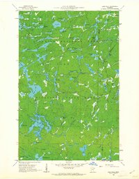 1960 Lake Polly1962 Print · USGSThe northern wilderness of the Arrowhead region is captured here in the early 1960s, showing a complex network of glacial lakes and portage routes. Researchers can trace the courses of the Kawishiwi River and Louse River past landmarks like Adams Lake and Malberg Lake.4 unique versions available
 - 1960 Map of Kawishiwi Lake, 1962 Print
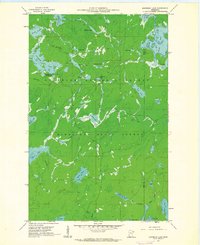 1960 Kawishiwi Lake1962 Print · USGSThe Superior National Forest at the start of the 1960s was a dense wilderness of interconnected waterways and glacial basins. Outdoor enthusiasts and local historians can trace the primitive layout of the Kawishiwi Lake Campground or follow the remote reaches of Phoebe Lake and Coffee Lake.3 unique versions available
 - 1960 Map of Beth Lake, 1962 Print
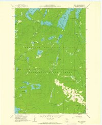 1960 Beth Lake1962 Print · USGSThe wilderness of Cook County is captured here in the early sixties, showing the transition between state and national forests. Outdoor historians and genealogists can trace the early road network and remote sites like Sawbill Campground, Beth Lake, and the upper reaches of the Temperance River.3 unique versions available
 - 1960 Map of Kelso Mountain, 1963 Print
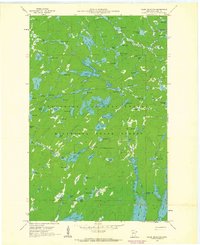 1960 Kelso Mountain1963 Print · USGSCook County's glacial interior is revealed in the early 1960s as a roadless expanse of lakes and forests. Researchers can trace the hydrography of the Frost River or locate the remote Lookout Tower atop Kelso Mountain.5 unique versions available
 - 1964 Map of Two Harbors
 1964 Two Harbors1964 Print · USGSThe North Shore of Lake Superior is captured here during the mid-1950s, a time of significant industrial mining growth and emerging tourism. Genealogists and historians can trace the rail lines of the Duluth Missabe and Iron Range and locate landmarks like Split Rock Light and the U S Air Force Radar Station.
End of results
Showing maps 1-5 of 5
Top cities near Schroeder Township
Top neighborhoods of Schroeder Township
Frequently asked questions
- What are the different types of historical maps available for Schroeder Township?
- What is the oldest map of Schroeder Township?
- Where can I purchase historical maps of Schroeder Township for my home or office?
- Where can I download high-res historical maps of Schroeder Township?
- Are there historical topographic maps available for Schroeder Township?
- Is there historical aerial imagery available for Schroeder Township?
- Where are historical maps of Schroeder Township sourced from?