1970s Maps of Baxter, Minnesota
Explore 3 historic maps of Baxter from the 1970s. These maps offer a rare glimpse into what life looked like during the 1970s — showing old roads, neighborhoods, homes, and landmarks that have changed or disappeared over time.
Whether you're researching your family's past, planning a metal detecting trip, or studying how Baxter's landscape evolved across the 1970s, these high-resolution maps are a powerful tool for exploring the history of this region.
- Focus on a specific era: All maps on this page are from the 1970s, giving you a focused view of this time period.
- See what’s changed: Compare century-old streets, trails, and buildings to today's modern landscape using overlays and satellite layers.
- Research with precision: Use these maps for genealogy, historical research, land use analysis, or educational projects.
- View, download, or print: Maps are fully viewable online in high resolution, and can be downloaded or printed for your own records.
Start exploring Baxter's history through authentic maps from the 1970s. This is your window into the past.
Baxter, MN maps
(3)- 1973 Map of Merrifield, 1976 Print
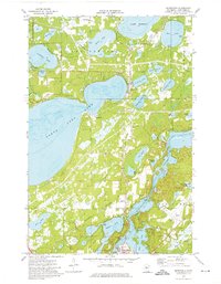 1973 Merrifield1976 Print · USGSThe lake country north of Brainerd is captured in the early 1970s, showing a transition from dense woodland and water to emerging infrastructure. Researchers can trace the Burlington Northern line through Merrifield and locate family sites at Lake Edward Cemetery.2 unique versions available
 - 1973 Map of Gull Lake, 1976 Print
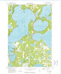 1973 Gull Lake1976 Print · USGSThe Brainerd Lakes area thrived as a premier mid-century vacation destination, shaped by its vast waterways and the expansion of the Highway 371 corridor. Genealogists and historians can trace the development of Nisswa, the Donnybrooke Speedway, and historic youth camps like Camp Lincoln.2 unique versions available
 - 1973 Map of Brainerd, 1976 Print
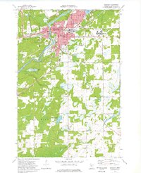 1973 Brainerd1976 Print · USGSThe Brainerd lakes area was a bustling regional center during the 1970s, as urban expansion reached toward Baxter and the Mississippi River. Genealogists and local historians can trace the foundations of the community through the sites of the Brainerd State Hospital, Evergreen Cem, and numerous historic schools.2 unique versions available
End of results
Showing maps 1-3 of 3
Top cities near Baxter
- Brainerd historical maps
- Nisswa historical maps
- Sylvan historical maps
- Pequot Lakes historical maps
- Crow Wing historical maps
- Lake Shore historical maps
See more
Top neighborhoods of Baxter
Frequently asked questions
- What are the different types of historical maps available for Baxter?
- What is the oldest map of Baxter?
- Where can I purchase historical maps of Baxter for my home or office?
- Where can I download high-res historical maps of Baxter?
- Are there historical topographic maps available for Baxter?
- Is there historical aerial imagery available for Baxter?
- Where are historical maps of Baxter sourced from?