1960s Maps of Belle Creek Township, Minnesota
Explore 4 historic maps of Belle Creek Township from the 1960s. These maps offer a rare glimpse into what life looked like during the 1960s — showing old roads, neighborhoods, homes, and landmarks that have changed or disappeared over time.
Whether you're researching your family's past, planning a metal detecting trip, or studying how Belle Creek Township's landscape evolved across the 1960s, these high-resolution maps are a powerful tool for exploring the history of this region.
- Focus on a specific era: All maps on this page are from the 1960s, giving you a focused view of this time period.
- See what’s changed: Compare century-old streets, trails, and buildings to today's modern landscape using overlays and satellite layers.
- Research with precision: Use these maps for genealogy, historical research, land use analysis, or educational projects.
- View, download, or print: Maps are fully viewable online in high resolution, and can be downloaded or printed for your own records.
Start exploring Belle Creek Township's history through authentic maps from the 1960s. This is your window into the past.
Belle Creek Township, MN maps
(4)- 1968 Map of Zumbrota, 1970 Print
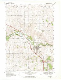 1968 Zumbrota1970 Print · USGSZumbrota and its surrounding townships are captured in the late sixties as the region's rail and agricultural patterns remained clearly defined. Genealogists and local historians can trace legacy sites like St Johns Ch, United Cem, and the small community of Forest Mills.2 unique versions available
 - 1968 Map of Wanamingo, 1970 Print
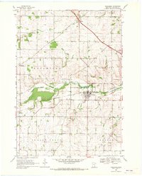 1968 Wanamingo1970 Print · USGSGoodhue County comes into focus in the late sixties as the rail-and-river economy centers on the town of Wanamingo. Local historians can trace family ties at Trinity Cem and Dale Cem, or follow the Chicago Milwaukee St Paul and Pacific railroad through the valley.2 unique versions available
 - 1968 Map of White Rock, 1970 Print
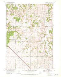 1968 White Rock1970 Print · USGSGoodhue County in the late sixties reveals a landscape of wooded ridges and tight-knit rural communities. Genealogists and local historians can trace the foundations of Wastedo and White Rock, locating specific landmarks like Spring Garden Ch and Wastedo Sch.2 unique versions available
 - 1968 Map of Goodhue West, 1970 Print
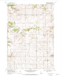 1968 Goodhue West1970 Print · USGSGoodhue County agriculture and industry are captured here in the late sixties as traditional rail lines gave way to modern roads. Genealogists can trace family roots through several country burial grounds like Hope Cem and Swedish Cem or locate the old St Columbkille Ch.
End of results
Showing maps 1-4 of 4
Top cities near Belle Creek Township
- Red Wing historical maps
- Cannon Falls historical maps
- Pine Island historical maps
- Zumbrota historical maps
- Trenton historical maps
- Wanamingo historical maps
See more
Top neighborhoods of Belle Creek Township
Frequently asked questions
- What are the different types of historical maps available for Belle Creek Township?
- What is the oldest map of Belle Creek Township?
- Where can I purchase historical maps of Belle Creek Township for my home or office?
- Where can I download high-res historical maps of Belle Creek Township?
- Are there historical topographic maps available for Belle Creek Township?
- Is there historical aerial imagery available for Belle Creek Township?
- Where are historical maps of Belle Creek Township sourced from?