
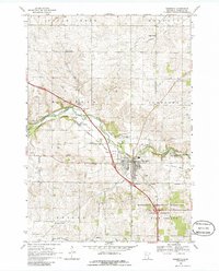
1968 Map of Zumbrota
USGS Topo · Published 1970About this map
The North Fork Zumbro River flows through a landscape defined by agricultural order and early industrial extraction in this late 1960s survey. The town of Zumbrota serves as a central hub, where the Chicago Milwaukee St Paul and Pacific Railroad line meets an extensive network of country roads. Local history is anchored by rural landmarks such as St Johns Ch and Lands Ch, while smaller settlements like Forest Mills, White Willow, and Roscoe Center dot the surrounding townships. The area's topography is marked by several Gravel Pits and specific Claypits west of town, suggesting the importance of local material resources. To the south and east, the map detail transitions into the protected timberlands of the Pine Island State Forest and the Minnesota Memorial Hardwood State Forest, bordering the winding course of the Zumbro River.
Find a feature on this map
32 named features on this map. Tap any name to fly to it.
Don’t see what you’re looking for? This feature index may not catch every label — zoom into the map to look around manually.
Map Details
Editions of this 1968 Zumbrota Map
2 editions found
Other maps of this area

1953 · Saint Paul
USGS Topo · 1:250,000

1959 · Saint Paul
USGS Topo · 1:250,000

1965 · Concord
USGS Topo · 1:24,000

1965 · Oronoco
USGS Topo · 1:24,000

1965 · Pine Island
USGS Topo · 1:24,000

1968 · Goodhue East
USGS Topo · 1:24,000

1968 · Mazeppa
USGS Topo · 1:24,000

1968 · Wanamingo
USGS Topo · 1:24,000

1968 · White Rock
USGS Topo · 1:24,000
1968 · Goodhue West
USGS Topo · 1:24,000