
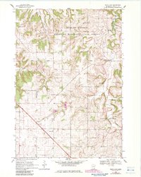
1968 Map of White Rock
USGS Topo · Published 1970About this map
Minnesota Memorial Hardwood State Forest dominates the northern reaches of this Goodhue County landscape, where the deeply incised Clark Valley and numerous ridges define the terrain. The map captures a rural Minnesota community centered around small agricultural hubs and local institutions during the late 1960s. The settlement of White Rock sits on the eastern edge of the forest boundary, while further south, the community of Wastedo is anchored by the Wastedo Sch and a nearby Townhall.
Find a feature on this map
19 named features on this map. Tap any name to fly to it.
Don’t see what you’re looking for? This feature index may not catch every label — zoom into the map to look around manually.
Map Details
Editions of this 1968 White Rock Map
2 editions found
Other maps of this area

1944 · Red Wing
USGS Topo · 1:62,500

1952 · Red Wing
USGS Topo · 1:62,500

1953 · Saint Paul
USGS Topo · 1:250,000

1957 · Hastings
USGS Topo · 1:62,500

1959 · Saint Paul
USGS Topo · 1:250,000

1968 · Zumbrota
USGS Topo · 1:24,000

1968 · Kenyon
USGS Topo · 1:24,000

1968 · Sogn
USGS Topo · 1:24,000

1968 · Wanamingo
USGS Topo · 1:24,000
1968 · Goodhue West
USGS Topo · 1:24,000