
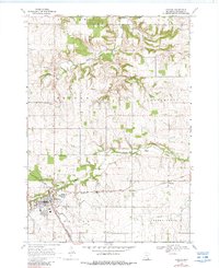
1968 Map of Kenyon
USGS Topo · Published 1970About this map
The city of Kenyon serves as the primary hub on this late-1960s survey, where the North Fork Zumbro River and a complex rail junction meet. Two major lines, the Chicago and North Western and the Chicago Milwaukee St Paul and Pacific, cross paths here, reflecting the importance of agricultural transport in Goodhue County. Beyond the town center, the landscape is defined by the rural townships of Holden and Wanamingo, where long-standing community markers like the Holden Ch and Little Cannon Cem remain key landmarks. Smaller settlements like Nansen and Bombay appear as distinct crossroads, while the terrain's industrial utility is evidenced by a Quarry, a Gravel Pit, and a Sandpit scattered across the river valleys. This map provides a clear record of the area's mid-century rural infrastructure before modern highway developments and rail consolidations further altered the local geography.
Find a feature on this map
28 named features on this map. Tap any name to fly to it.
Don’t see what you’re looking for? This feature index may not catch every label — zoom into the map to look around manually.
Map Details
Editions of this 1968 Kenyon Map
2 editions found
Other maps of this area

1953 · Saint Paul
USGS Topo · 1:250,000

1959 · Saint Paul
USGS Topo · 1:250,000

1960 · Dennison
USGS Topo · 1:24,000

1960 · Nerstrand
USGS Topo · 1:24,000

1962 · Moland
USGS Topo · 1:24,000

1965 · Concord
USGS Topo · 1:24,000

1965 · West Concord
USGS Topo · 1:24,000

1968 · Sogn
USGS Topo · 1:24,000

1968 · Wanamingo
USGS Topo · 1:24,000

1968 · White Rock
USGS Topo · 1:24,000