
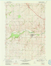
1968 Map of Wanamingo
USGS Topo · Published 1970About this map
Wanamingo serves as the central hub of this late-1960s landscape, situated at the confluence of several townships including Minneola and Wanamingo. The Chicago Milwaukee St Paul and Pacific railroad tracks provide a clear industrial axis through the town, paralleling the North Fork Zumbro River. This area of Goodhue County is defined by its small agricultural settlements and the deep-seated presence of local institutions, from the Townhall to several historic burial grounds like Wanamingo Cem and Trinity Cem.
Find a feature on this map
23 named features on this map. Tap any name to fly to it.
Don’t see what you’re looking for? This feature index may not catch every label — zoom into the map to look around manually.
Map Details
Editions of this 1968 Wanamingo Map
2 editions found
Other maps of this area

1953 · Saint Paul
USGS Topo · 1:250,000

1959 · Saint Paul
USGS Topo · 1:250,000

1965 · Concord
USGS Topo · 1:24,000

1965 · West Concord
USGS Topo · 1:24,000

1965 · Pine Island
USGS Topo · 1:24,000

1968 · Zumbrota
USGS Topo · 1:24,000

1968 · Kenyon
USGS Topo · 1:24,000

1968 · Sogn
USGS Topo · 1:24,000

1968 · White Rock
USGS Topo · 1:24,000
1968 · Goodhue West
USGS Topo · 1:24,000