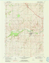
1968 Map of Wanamingo
USGS Topo · Published 1991About this map
The North Fork Zumbro River snakes through the center of this Goodhue County landscape, serving as a geographic anchor for the village of Wanamingo. This late 1960s environment shows a distinct agricultural and transportation pattern, where the Chicago Milwaukee St Paul and Pacific railroad tracks parallel the river's course to serve local industry. Smaller settlements like Hader and Aspelund dot the periphery, connected by a network of rural roads that link scattered landmarks such as Dale Ch and the township Townhall. The map detail reveals the importance of the river valley for local operations, evidenced by several Gravel Pit sites and a Quarry near the South Fork Zumbro River junction. For local historians, the inclusion of the Wanamingo Cem and Trinity Cem provides specific points of interest for genealogical research in these rural townships.
Find a feature on this map
22 named features on this map. Tap any name to fly to it.
Don’t see what you’re looking for? This feature index may not catch every label — zoom into the map to look around manually.
Map Details
Editions of this 1968 Wanamingo Map
2 editions found
Other maps of this area

1953 · Saint Paul
USGS Topo · 1:250,000

1959 · Saint Paul
USGS Topo · 1:250,000

1965 · Concord
USGS Topo · 1:24,000

1965 · West Concord
USGS Topo · 1:24,000

1965 · Pine Island
USGS Topo · 1:24,000

1968 · Zumbrota
USGS Topo · 1:24,000

1968 · Kenyon
USGS Topo · 1:24,000

1968 · Sogn
USGS Topo · 1:24,000

1968 · Wanamingo
USGS Topo · 1:24,000

1968 · White Rock
USGS Topo · 1:24,000