
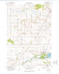
1960 Map of Dennison
USGS Topo · Published 1961About this map
The Chicago Great Western railroad serves as the primary corridor for this rural landscape, linking the small agricultural hubs of Dennison and Stanton. Located at the intersection of Dakota, Rice, and Goodhue counties, the map highlights the fertile drainage basins of the Cannon River, Spring Creek, and Prairie Creek. The arrangement of farmland is detailed through fine red dashed lines indicating field and fence lines, a characteristic of the mid-century agricultural organization in this part of Minnesota.
Find a feature on this map
19 named features on this map. Tap any name to fly to it.
Don’t see what you’re looking for? This feature index may not catch every label — zoom into the map to look around manually.
Map Details
Editions of this 1960 Dennison Map
This is the sole edition of this map. No revisions or reprints were ever made.
Other maps of this area

1953 · Saint Paul
USGS Topo · 1:250,000

1957 · Farmington
USGS Topo · 1:62,500

1957 · Hastings
USGS Topo · 1:62,500

1959 · Saint Paul
USGS Topo · 1:250,000

1960 · Northfield
USGS Topo · 1:24,000

1960 · Cannon City
USGS Topo · 1:24,000

1960 · Nerstrand
USGS Topo · 1:24,000

1968 · Kenyon
USGS Topo · 1:24,000

1968 · Sogn
USGS Topo · 1:24,000
1974 · Randolph
USGS Topo · 1:24,000