
1962 Map of Moland
USGS Topo · Published 1964About this map
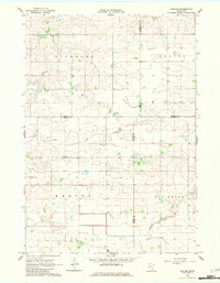
The farming community of Moland sits at the intersection of Rice, Steele, Goodhue, and Dodge counties, anchoring a landscape shaped by the headwaters of the Middle Fork Zumbro River. This 1962 field-checked survey reveals a rural settlement pattern defined by small social centers like Richland Center and essential community landmarks such as Moland Ch and the nearby Townhall. The terrain is drained by Rush Creek and the man-made County Ditch No 2, indicating the historical importance of agricultural drainage in this fertile region. For local historians, the presence of the Merton Cem and several school buildings labeled simply as Sch provides a clear map of the mid-century social geography. The map also includes a working Gravel Pit, reflecting the local industry required for maintaining the grid of section roads that divide the townships of Merton, Richland, and Ellington.
Find a feature on this map
19 named features on this map. Tap any name to fly to it.
Don’t see what you’re looking for? This feature index may not catch every label — zoom into the map to look around manually.
Map Details
Editions of this 1962 Moland Map
2 editions found
Other maps of this area

1953 · Saint Paul
USGS Topo · 1:250,000

1959 · Saint Paul
USGS Topo · 1:250,000

1960 · Cannon City
USGS Topo · 1:24,000

1960 · Nerstrand
USGS Topo · 1:24,000

1962 · Medford East
USGS Topo · 1:24,000

1962 · Owatonna
USGS Topo · 1:24,000

1962 · Owatonna SE
USGS Topo · 1:24,000

1965 · Claremont
USGS Topo · 1:24,000

1965 · West Concord
USGS Topo · 1:24,000

1968 · Kenyon
USGS Topo · 1:24,000