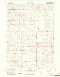
1962 Map of Moland
USGS Topo · Published 1982About this map
Richland Center and Moland serve as the primary focal points of this rural landscape where Rice, Goodhue, Steele, and Dodge counties converge. This early 1960s survey documents a well-established agricultural grid defined by local institutional landmarks such as the Richland Center Sch, the Townhall, and the Moland Ch. The topography is shaped by the winding courses of Rush Creek and the Middle Fork Zumbro River, which cut through the undulating terrain of the Richland and Ellington townships. Genealogy and local history researchers will find value in the precise locations of the Moland Ch Cem and Merton Cem. The presence of County Ditch No 2 and a scattered Gravel Pit illustrates the ongoing land management and small-scale resource extraction typical of southern Minnesota farm country during this era.
Find a feature on this map
20 named features on this map. Tap any name to fly to it.
Don’t see what you’re looking for? This feature index may not catch every label — zoom into the map to look around manually.
Map Details
Editions of this 1962 Moland Map
2 editions found
Other maps of this area

1953 · Saint Paul
USGS Topo · 1:250,000

1959 · Saint Paul
USGS Topo · 1:250,000

1960 · Cannon City
USGS Topo · 1:24,000

1960 · Nerstrand
USGS Topo · 1:24,000

1962 · Medford East
USGS Topo · 1:24,000

1962 · Owatonna
USGS Topo · 1:24,000

1962 · Moland
USGS Topo · 1:24,000

1962 · Owatonna SE
USGS Topo · 1:24,000

1965 · Claremont
USGS Topo · 1:24,000

1965 · West Concord
USGS Topo · 1:24,000