
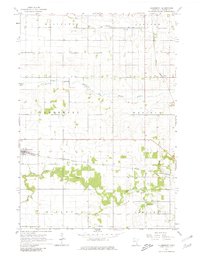
1965 Map of Claremont
USGS Topo · Published 1966About this map
Claremont and the smaller settlement of Eden serve as the primary focal points of this mid-1960s agricultural survey in Dodge County. The landscape is defined by its sophisticated drainage and transport networks, including Judicial Ditch No 1 and numerous meandering watercourses such as Dodge Center Creek and the South Branch Middle Fork Zumbro River. This era captures the height of rail-dependent commerce for these rural communities, with the Chicago and North Western and the Chicago Great Western railroads both traversing the territory. Genealogists can find localized historical markers like the Claremont Street Cem, while the industrial presence is marked by scattered gravel pits. The map illustrates a well-ordered grid of townships, including Ellington, Concord, Wasioja, and Ripley, reflecting the settled, productive nature of the Minnesota prairie during this period.
Find a feature on this map
17 named features on this map. Tap any name to fly to it.
Don’t see what you’re looking for? This feature index may not catch every label — zoom into the map to look around manually.
Map Details
Editions of this 1965 Claremont Map
2 editions found
Other maps of this area

1953 · Saint Paul
USGS Topo · 1:250,000

1954 · Mason City
USGS Topo · 1:250,000

1957 · Mason City
USGS Topo · 1:250,000

1958 · Mason City
USGS Topo · 1:250,000

1959 · Saint Paul
USGS Topo · 1:250,000

1962 · Moland
USGS Topo · 1:24,000

1962 · Owatonna SE
USGS Topo · 1:24,000

1965 · Dodge Center
USGS Topo · 1:24,000

1965 · Concord
USGS Topo · 1:24,000

1965 · West Concord
USGS Topo · 1:24,000