Old Maps of Rice County, Minnesota
Explore 117 old maps of Rice County, spanning from 1953 to today. These high-resolution historic maps reveal how streets, neighborhoods, landmarks, and natural features evolved over time — perfect for genealogy, metal detecting, research, and local history exploration.
What you can do with these maps:
- See how Rice County changed over time: Compare historical maps to modern-day views to trace roads, homesites, rail lines & more.
- View detailed metadata: Each map includes creators, publishers, year, scale, and archive source.
- Overlay maps with satellite & LiDAR: Visualize the past alongside modern tools to explore terrain & human change.
- Trusted historical sources: Maps sourced from the USGS, Library of Congress, and other archives.
- Access maps your way: View online, download high-res files, or order prints for personal or research use.
Start exploring old maps of Rice County to uncover forgotten places, hidden landmarks, and the deep history beneath your feet.
Rice County, MN maps
(117)- 1953 Map of Saint Paul, 1964 Print
 1953 Saint Paul1964 Print · USGSThe Twin Cities and the Mississippi River valley are captured here at a mid-century turning point. Trace the early growth of Minneapolis and Saint Paul alongside landmarks like Lake Minnetonka and the St Croix River.4 unique versions available
 - 1957 Map of Prior Lake, 1958 Print
 1957 Prior Lake1958 Print · USGSScott and Rice Counties appear here in the late 1950s, showing a region defined by its numerous glacial lakes and small farming hamlets. Genealogists and researchers can trace rural school locations and historic churches such as St Catherine Ch, Elko, and several noted sites like School No 52 (Abandoned).2 unique versions available
 - 1957 Map of New Prague, 1959 Print
 1957 New Prague1959 Print · USGSScott and Le Sueur Counties in the late fifties reveal a landscape of deep-rooted parish settlements and thriving river-valley agriculture. Genealogists can trace family footprints through rural sites like East Union, St Benedict, and the St Josephs Sch Cem.2 unique versions available
 - 1959 Map of Saint Paul
 1959 Saint Paul1959 Print · USGSThe Twin Cities and southeastern Minnesota appear here in the late fifties, showing the peak of the rail era and post-war suburban growth. Genealogists can trace family footprints near Lake Minnetonka, the Univ Of Minn Rosemount Research Center, or the growing neighborhoods of Richfield.2 unique versions available
 - 1960 Map of Faribault, 1961 Print
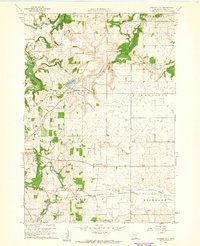
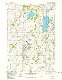
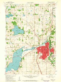 1960 Faribault1961 Print · USGSFaribault at the start of the 1960s is a dense hub of institutional life and rail commerce at the edge of Minnesota's lake country. Genealogists and historians can locate specific school districts and landmarks like the Minnesota Sch for the Deaf, Shattuck Sch, and Calvary Cemetery.
 - 1960 Map of Northfield, 1961 Print
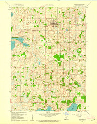
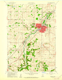 1960 Northfield1961 Print · USGSNorthfield and its surrounding townships are shown at a peak of mid-century growth, serving as a vital rail junction between the Twin Cities and southern Minnesota. Researchers can trace institutional grounds at St Olaf College and Carleton College or find rural landmarks like Little Prairie Ch and Dundas.2 unique versions available
 - 1960 Map of Cannon City, 1961 Print
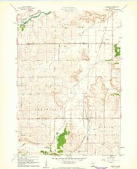
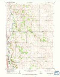
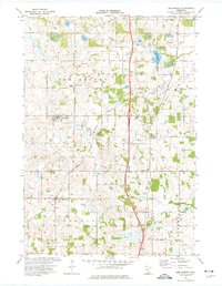
 1960 Cannon City1961 Print · USGSRice County farmland and small crossroads settlements are captured here in the early sixties. Researchers can trace the rail corridors of the Chicago and North Western or locate local landmarks like Crystal Lake and the Wide Awake Sch.2 unique versions available
 - 1960 Map of Dennison, 1961 Print
 1960 Dennison1961 Print · USGSSoutheast Minnesota's agricultural heartland is documented here at the start of the 1960s. Family historians and researchers can trace the rail-side growth of Dennison and Stanton, locate the Prairie Creek Cem, and find landmarks like Carleton Airport.
 - 1960 Map of Shieldsville, 1961 Print
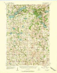
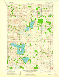
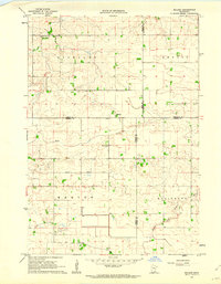
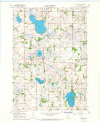
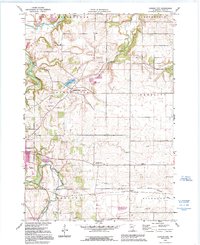
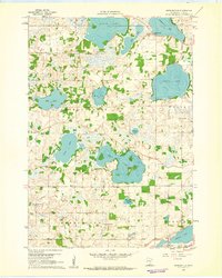 1960 Shieldsville1961 Print · USGSShieldsville and the surrounding lake country of Rice County are captured here in the early sixties. Researchers can trace rural school districts like Lake View Sch and Trinity Sch, or locate family landmarks near Caron Lake and Willing Lake.4 unique versions available
 - 1960 Map of Lonsdale, 1961 Print
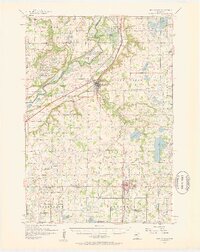
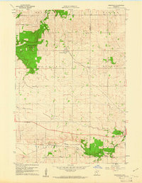
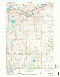
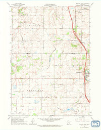
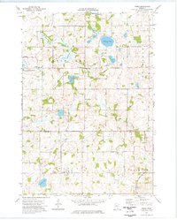
 1960 Lonsdale1961 Print · USGSLonsdale and the surrounding Rice County townships are captured in the early sixties as a landscape of rural schoolhouses and rail-side villages. You can trace family footprints at Trondjem, Calvary Hill Cem, and numerous school sites like Meehl Sch.2 unique versions available
 - 1960 Map of Little Chicago, 1961 Print
 1960 Little Chicago1961 Print · USGSRice and Dakota Counties are shown in the early sixties, a time when three major railroads still converged in the southeastern corner. Genealogists can trace rural roots at Christdala Ch, Township Cem, and the old Millersburg townsite.2 unique versions available
 - 1960 Map of Nerstrand, 1961 Print
 1960 Nerstrand1961 Print · USGSSoutheastern Minnesota farmland at the start of the 1960s reveals a landscape of rural churches and competing rail lines. Local historians can trace family roots at Valley Grove Ch, explore the village of Nerstrand, or locate old sites near Falls Creek.2 unique versions available
 - 1962 Map of Medford East, 1963 Print
 1962 Medford East1963 Print · USGSSteel County agricultural and rail life in the early sixties is centered on the busy river corridor between Medford and Clinton Falls. Genealogists and local historians can trace family locations near Perry Sch, the Rock Sch, or cemeteries like Oak Hill Cem and Eklund Cem.
 - 1962 Map of Morristown, 1963 Print
 1962 Morristown1963 Print · USGSRice and Waseca counties in the early sixties reveal a landscape of river-town commerce and rural parish life. Researchers can trace family roots at Riverside Cemetery, locate the Chicago Great Western rail line, or find the Blooming Grove Church.2 unique versions available
 - 1962 Map of Moland, 1964 Print
 1962 Moland1964 Print · USGSSteele and Rice counties are captured in the early sixties, showing a landscape of established farmsteads and rural social hubs. Genealogists can locate Richland Center, the Merton Cem, and the community surrounding Moland Ch.2 unique versions available
 - 1962 Map of Medford West, 1964 Print
 1962 Medford West1964 Print · USGSSteele and Rice Counties are captured here in the early sixties, showing the agricultural transformation of the southern Minnesota prairie. Researchers can trace the legacy of rural education and faith through sites like Sammon Sch, Trinity Cem, and the vanished Pelican Lake Bed.
 - 1966 Map of Montgomery, 1967 Print
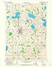 1966 Montgomery1967 Print · USGSLe Sueur and Rice counties are captured here in the mid-sixties, centered on the rail hub of Montgomery. Genealogists and local historians can trace family roots through numerous sites like Bohemian Cem, St Michael Cem, and the old High School.2 unique versions available
 - 1966 Map of Waterville, 1968 Print
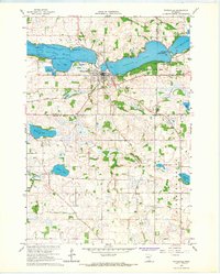 1966 Waterville1968 Print · USGSWaterville sits at the center of this mid-century survey, where the railroads and the Cannon River system define the local economy. Genealogists can trace rural roots through family-named landmarks like McPete Point and several old graveyards including Iosco Cem and Ebenezer Cem.2 unique versions available
 - 1966 Map of Kilkenny, 1968 Print
 1966 Kilkenny1968 Print · USGSThe lake-dotted landscape of Le Sueur County is captured here in the mid-1960s, centered on the railroad town of Kilkenny. Researchers can trace old family lines near Calvary Cem and locate historic hamlets like Doyle and Rogers along the rail line.2 unique versions available
 - 1974 Map of New Market, 1976 Print
 1974 New Market1976 Print · USGSThe rural borderlands of Scott and Rice counties are captured here in the mid-seventies, showing a landscape of small farming towns and expanding regional transit. Genealogists and local historians can trace the roads to Solor Ch, West Christiania Cem, and the settlement of Hazelwood.
 - 1974 Map of Veseli, 1976 Print
 1974 Veseli1976 Print · USGSThe rural lake country of Scott and Rice Counties is captured here in the mid-1970s, centered on the village of Veseli. Family historians can locate landmarks like St Johns Cem, the Sharkey Landing Field, and the Milwaukee Road rail line.
 - 1981 Map of New Prague, 1982 Print
 1981 New Prague1982 Print · USGSNew Prague and the surrounding lake country of Scott and Le Sueur counties are shown here in the early eighties as the area maintained its agricultural and rail roots. Genealogists and local historians can trace the town grid to Sancti Wenceslai Cem, follow the Chicago and North Western tracks, or locate rural centers like St Benedict and St Patrick.
 - 1985 Map of Saint Paul
 1985 Saint Paul1985 Print · USGSThe Twin Cities metropolitan area and its southern suburbs are captured here in the mid-eighties as the urban landscape expanded toward the Minnesota River. Researchers can trace the layout of the Fort Snelling Military Reservation, find local landmarks like St Benedict Church, and study the rail routes of the Soo Line.2 unique versions available
 - 1985 Map of Faribault, 1986 Print
 1985 Faribault1986 Print · USGSThe Minnesota River valley and the glacial lake country of Rice and Le Sueur counties are shown here in the mid-1980s. Researchers can trace the academic grounds of St Olaf College or find old crossroads like Trondhjem and Little Chicago.2 unique versions available
 - 1991 Map of Cannon City, 1995 Print
 1991 Cannon City1995 Print · USGSRice County's agricultural landscape is captured here in the early nineties, showing the convergence of the Cannon and Straight Rivers. Genealogists can locate rural school sites like Wide Awake Sch and small settlements including Prairieville and Ruskin.
Showing maps 1-25 of 117
Top cities of Rice County
- Faribault historical maps
- Northfield historical maps
- Lonsdale historical maps
- Webster historical maps
- Warsaw historical maps
- Wheatland historical maps
See more
Frequently asked questions
- What are the different types of historical maps available for Rice County?
- What is the oldest map of Rice County?
- Where can I purchase historical maps of Rice County for my home or office?
- Where can I download high-res historical maps of Rice County?
- Are there historical topographic maps available for Rice County?
- Is there historical aerial imagery available for Rice County?
- Where are historical maps of Rice County sourced from?