
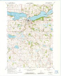
1966 Map of Waterville
USGS Topo · Published 1968About this map
Waterville serves as the hub of this mid-1960s landscape, positioned where the Chicago Great Western railroad tracks meet the waters connecting Tetonka Lake and Sakatah Lake. The town's infrastructure is detailed, including a Fish Hatchery and local schools, while the surrounding rural townships of Iosco and Blooming Grove are dotted with family-named landmarks and country cemeteries.
Find a feature on this map
43 named features on this map. Tap any name to fly to it.
Don’t see what you’re looking for? This feature index may not catch every label — zoom into the map to look around manually.
Map Details
Editions of this 1966 Waterville Map
2 editions found
Other maps of this area

1953 · Saint Paul
USGS Topo · 1:250,000

1959 · Saint Paul
USGS Topo · 1:250,000

1960 · Shieldsville
USGS Topo · 1:24,000

1962 · Morristown
USGS Topo · 1:24,000

1962 · Meriden
USGS Topo · 1:24,000

1966 · Waseca
USGS Topo · 1:24,000

1966 · Janesville
USGS Topo · 1:24,000

1966 · Cordova
USGS Topo · 1:24,000

1966 · Elysian
USGS Topo · 1:24,000
1966 · Kilkenny
USGS Topo · 1:24,000