1990s Maps of Rice County, Minnesota
Explore 3 historic maps of Rice County from the 1990s. These maps offer a rare glimpse into what life looked like during the 1990s — showing old roads, neighborhoods, homes, and landmarks that have changed or disappeared over time.
Whether you're researching your family's past, planning a metal detecting trip, or studying how Rice County's landscape evolved across the 1990s, these high-resolution maps are a powerful tool for exploring the history of this region.
- Focus on a specific era: All maps on this page are from the 1990s, giving you a focused view of this time period.
- See what’s changed: Compare century-old streets, trails, and buildings to today's modern landscape using overlays and satellite layers.
- Research with precision: Use these maps for genealogy, historical research, land use analysis, or educational projects.
- View, download, or print: Maps are fully viewable online in high resolution, and can be downloaded or printed for your own records.
Start exploring Rice County's history through authentic maps from the 1990s. This is your window into the past.
Rice County, MN maps
(3)- 1991 Map of Cannon City, 1995 Print
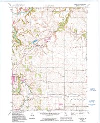 1991 Cannon City1995 Print · USGSRice County's agricultural landscape is captured here in the early nineties, showing the convergence of the Cannon and Straight Rivers. Genealogists can locate rural school sites like Wide Awake Sch and small settlements including Prairieville and Ruskin.
 - 1991 Map of Faribault, 1995 Print
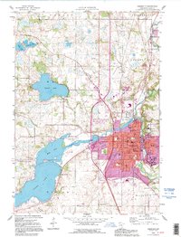 1991 Faribault1995 Print · USGSThe Rice County seat at the start of the nineties reveals a unique landscape of specialized institutions and riverfront industry. Genealogists can trace several regional burial sites like Maple Lawn Cemetery and locate historic campuses including the Minnesota Sch for the Deaf.
 - 1991 Map of Northfield, 1995 Print
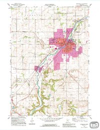 1991 Northfield1995 Print · USGSNorthfield and the Cannon River valley are seen here in the early nineties, a period of established academic and civic growth. Researchers can trace the sprawling grounds of St Olaf College and Carleton College, or locate rural landmarks like Little Prairie Ch and the hamlet of Waterford.
End of results
Showing maps 1-3 of 3
Top cities of Rice County
- Faribault historical maps
- Northfield historical maps
- Lonsdale historical maps
- Webster historical maps
- Warsaw historical maps
- Wheatland historical maps
See more
Frequently asked questions
- What are the different types of historical maps available for Rice County?
- What is the oldest map of Rice County?
- Where can I purchase historical maps of Rice County for my home or office?
- Where can I download high-res historical maps of Rice County?
- Are there historical topographic maps available for Rice County?
- Is there historical aerial imagery available for Rice County?
- Where are historical maps of Rice County sourced from?