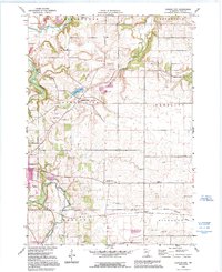
1991 Map of Cannon City
USGS Topo · Published 1995About this map
The Cannon River and Straight River converge at the edge of Faribault in this portrait of Rice County's agricultural heartland. The 1991 revisions, highlighted in purple, document a landscape where small rural settlements like Cannon City and Prairieville serve as hubs for a grid of section roads and school districts. The distribution of local education is particularly well-preserved here, with rural landmarks such as Wide Awake Sch, School No 1773, and Wheeling Sch scattered throughout the townships. To the south, the North Branch Zumbro River begins its course, while the Faribault State Wildlife Management Area and the grounds of the State Hospital mark the transition from the city's outskirts to the surrounding farmsteads. Dozens of gravel pits and quarries underscore the importance of local mineral extraction in shaping the area's contemporary geography.
Find a feature on this map
27 named features on this map. Tap any name to fly to it.
Don’t see what you’re looking for? This feature index may not catch every label — zoom into the map to look around manually.
Map Details
Editions of this 1991 Cannon City Map
This is the sole edition of this map. No revisions or reprints were ever made.
Other maps of this area

1953 · Saint Paul
USGS Topo · 1:250,000

1959 · Saint Paul
USGS Topo · 1:250,000

1960 · Faribault
USGS Topo · 1:24,000

1960 · Northfield
USGS Topo · 1:24,000

1960 · Cannon City
USGS Topo · 1:24,000

1960 · Dennison
USGS Topo · 1:24,000

1960 · Little Chicago
USGS Topo · 1:24,000

1960 · Nerstrand
USGS Topo · 1:24,000

1962 · Medford East
USGS Topo · 1:24,000

1962 · Moland
USGS Topo · 1:24,000