1970s Maps of Welch Township, Minnesota
Explore 4 historic maps of Welch Township from the 1970s. These maps offer a rare glimpse into what life looked like during the 1970s — showing old roads, neighborhoods, homes, and landmarks that have changed or disappeared over time.
Whether you're researching your family's past, planning a metal detecting trip, or studying how Welch Township's landscape evolved across the 1970s, these high-resolution maps are a powerful tool for exploring the history of this region.
- Focus on a specific era: All maps on this page are from the 1970s, giving you a focused view of this time period.
- See what’s changed: Compare century-old streets, trails, and buildings to today's modern landscape using overlays and satellite layers.
- Research with precision: Use these maps for genealogy, historical research, land use analysis, or educational projects.
- View, download, or print: Maps are fully viewable online in high resolution, and can be downloaded or printed for your own records.
Start exploring Welch Township's history through authentic maps from the 1970s. This is your window into the past.
Welch Township, MN maps
(4)- 1974 Map of Miesville, 1978 Print
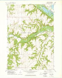
 1974 Miesville1978 Print · USGSSoutheast of St. Paul in the 1970s, the Cannon River valley reveals a transition from upland farming to deep river bluffs. Genealogists and historians can trace family locations near the Mineral Springs Sanatorium, Cannon River Cemetery, and the village of Miesville.
 - 1974 Map of Diamond Bluff West, 1978 Print
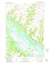 1974 Diamond Bluff West1978 Print · USGSThe Mississippi River valley serves as a borderland between Wisconsin and Minnesota in this mid-seventies survey of the Diamond Bluff area. Local historians can trace the Prairie Island Indian Reservation and find landmarks like St Johns Ch and the Prairie Island Cem.
 - 1974 Map of Welch, 1978 Print
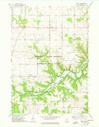
 1974 Welch1978 Print · USGSGoodhue County in the 1970s reveals a diverse landscape where the Cannon River meets the expansive backwaters of the Mississippi. Genealogists and local historians can trace the rural communities of Welch and Vasa, alongside landmarks like Mt Carmel Cem and the Burnside Sch.
 - 1974 Map of Hastings, 1978 Print
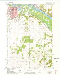 1974 Hastings1978 Print · USGSThe riverfront communities of Hastings and Prescott are shown in detail during the mid-seventies as they grew along the Mississippi and Vermillion rivers. Genealogists and local researchers can locate numerous historic sites, from the State Hospital Cem and St Boniface Ch to the OLD RAILROAD GRADE and local town halls.2 unique versions available
End of results
Showing maps 1-4 of 4
Top cities near Welch Township
- Cottage Grove historical maps
- Hastings historical maps
- Red Wing historical maps
- River Falls historical maps
- Prescott historical maps
- Cannon Falls historical maps
See more
Top neighborhoods of Welch Township
Frequently asked questions
- What are the different types of historical maps available for Welch Township?
- What is the oldest map of Welch Township?
- Where can I purchase historical maps of Welch Township for my home or office?
- Where can I download high-res historical maps of Welch Township?
- Are there historical topographic maps available for Welch Township?
- Is there historical aerial imagery available for Welch Township?
- Where are historical maps of Welch Township sourced from?