1990s Maps of Edina, Minnesota
Explore 1 historic maps of Edina from the 1990s. These maps offer a rare glimpse into what life looked like during the 1990s — showing old roads, neighborhoods, homes, and landmarks that have changed or disappeared over time.
Whether you're researching your family's past, planning a metal detecting trip, or studying how Edina's landscape evolved across the 1990s, these high-resolution maps are a powerful tool for exploring the history of this region.
- Focus on a specific era: All maps on this page are from the 1990s, giving you a focused view of this time period.
- See what’s changed: Compare century-old streets, trails, and buildings to today's modern landscape using overlays and satellite layers.
- Research with precision: Use these maps for genealogy, historical research, land use analysis, or educational projects.
- View, download, or print: Maps are fully viewable online in high resolution, and can be downloaded or printed for your own records.
Start exploring Edina's history through authentic maps from the 1990s. This is your window into the past.
Edina, MN maps
(1)- 1997 Map of Bloomington, 1999 Print
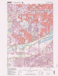 1997 Bloomington1999 Print · USGSThe Twin Cities' southern suburbs were fully established by the late nineties, from the bustling commerce of Bloomington to the residential streets of Savage. Trace local landmarks like the Minnesota Masonic Home, the Southtown Shopping Center, and the industrial docks at Port Cargill.
End of results
Showing maps 1-1 of 1
Top cities near Edina
- Minneapolis historical maps
- Saint Paul historical maps
- Bloomington historical maps
- Brooklyn Park historical maps
- Plymouth historical maps
- Eagan historical maps
See more
Top neighborhoods of Edina
- Braemar Hills historical maps
- Bredesen Park historical maps
- Creek Valley historical maps
- The Heights historical maps
- Cornelia South historical maps
- Dewey Hill historical maps
See more
Frequently asked questions
- What are the different types of historical maps available for Edina?
- What is the oldest map of Edina?
- Where can I purchase historical maps of Edina for my home or office?
- Where can I download high-res historical maps of Edina?
- Are there historical topographic maps available for Edina?
- Is there historical aerial imagery available for Edina?
- Where are historical maps of Edina sourced from?