1960s Maps of Indian Trails, Edina
Explore 2 historic maps of Indian Trails from the 1960s. These maps offer a rare glimpse into what life looked like during the 1960s — showing old roads, neighborhoods, homes, and landmarks that have changed or disappeared over time.
Whether you're researching your family's past, planning a metal detecting trip, or studying how Indian Trails's landscape evolved across the 1960s, these high-resolution maps are a powerful tool for exploring the history of this region.
- Focus on a specific era: All maps on this page are from the 1960s, giving you a focused view of this time period.
- See what’s changed: Compare century-old streets, trails, and buildings to today's modern landscape using overlays and satellite layers.
- Research with precision: Use these maps for genealogy, historical research, land use analysis, or educational projects.
- View, download, or print: Maps are fully viewable online in high resolution, and can be downloaded or printed for your own records.
Start exploring Indian Trails's history through authentic maps from the 1960s. This is your window into the past.
Indian Trails, Edina maps
(2)- 1967 Map of Hopkins, 1969 Print
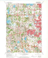 1967 Hopkins1969 Print · USGSSuburban expansion and civic institutions define this Hennepin County landscape during the late sixties. Genealogists and local historians can trace legacy sites like the Glen Lake State Sanatorium, Minnetonka Mills, and the Grand View Park Cemetery.5 unique versions available
 - 1967 Map of Eden Prairie, 1969 Print
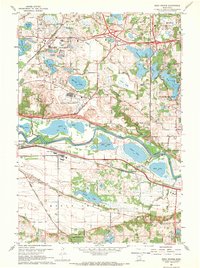 1967 Eden Prairie1969 Print · USGSThe Minnesota River valley near Eden Prairie and Bloomington shows a transition from agricultural life to mid-century suburbanization. Trace historical local landmarks like Bloomington Ferry, the Flying Cloud Airport, and Eden Prairie Cem.5 unique versions available
End of results
Showing maps 1-2 of 2
Frequently asked questions
- What are the different types of historical maps available for Indian Trails?
- What is the oldest map of Indian Trails?
- Where can I purchase historical maps of Indian Trails for my home or office?
- Where can I download high-res historical maps of Indian Trails?
- Are there historical topographic maps available for Indian Trails?
- Is there historical aerial imagery available for Indian Trails?
- Where are historical maps of Indian Trails sourced from?