1960s Maps of Prospect Knolls, Edina
Explore 4 historic maps of Prospect Knolls from the 1960s. These maps offer a rare glimpse into what life looked like during the 1960s — showing old roads, neighborhoods, homes, and landmarks that have changed or disappeared over time.
Whether you're researching your family's past, planning a metal detecting trip, or studying how Prospect Knolls's landscape evolved across the 1960s, these high-resolution maps are a powerful tool for exploring the history of this region.
- Focus on a specific era: All maps on this page are from the 1960s, giving you a focused view of this time period.
- See what’s changed: Compare century-old streets, trails, and buildings to today's modern landscape using overlays and satellite layers.
- Research with precision: Use these maps for genealogy, historical research, land use analysis, or educational projects.
- View, download, or print: Maps are fully viewable online in high resolution, and can be downloaded or printed for your own records.
Start exploring Prospect Knolls's history through authentic maps from the 1960s. This is your window into the past.
Prospect Knolls, Edina maps
(4)- 1967 Map of Minneapolis South, 1969 Print
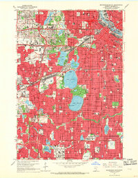 1967 Minneapolis South1969 Print · USGSThe Twin Cities suburbs and urban core are seen here during the late sixties, as the region's lakefronts and parkways matured. Researchers can trace the development of Southdale, locate family plots in Lakewood Cemetery, or study the rail corridors of the Great Northern.6 unique versions available
 - 1967 Map of Hopkins, 1969 Print
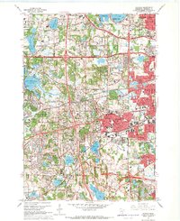 1967 Hopkins1969 Print · USGSSuburban expansion and civic institutions define this Hennepin County landscape during the late sixties. Genealogists and local historians can trace legacy sites like the Glen Lake State Sanatorium, Minnetonka Mills, and the Grand View Park Cemetery.5 unique versions available
 - 1967 Map of Bloomington, 1969 Print
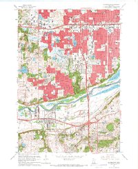 1967 Bloomington1969 Print · USGSThe Twin Cities suburbs experienced a surge of growth during the late sixties as residential developments filled the spaces between historic river towns. Genealogists and local historians can trace the footprint of community institutions like Bloomington Ferry Ch, Port Cargill, and the Minnesota Masonic Home.5 unique versions available
 - 1967 Map of Eden Prairie, 1969 Print
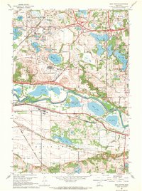 1967 Eden Prairie1969 Print · USGSThe Minnesota River valley near Eden Prairie and Bloomington shows a transition from agricultural life to mid-century suburbanization. Trace historical local landmarks like Bloomington Ferry, the Flying Cloud Airport, and Eden Prairie Cem.5 unique versions available
End of results
Showing maps 1-4 of 4
Frequently asked questions
- What are the different types of historical maps available for Prospect Knolls?
- What is the oldest map of Prospect Knolls?
- Where can I purchase historical maps of Prospect Knolls for my home or office?
- Where can I download high-res historical maps of Prospect Knolls?
- Are there historical topographic maps available for Prospect Knolls?
- Is there historical aerial imagery available for Prospect Knolls?
- Where are historical maps of Prospect Knolls sourced from?