1960s Maps of Maple Grove, Minnesota
Explore 3 historic maps of Maple Grove from the 1960s. These maps offer a rare glimpse into what life looked like during the 1960s — showing old roads, neighborhoods, homes, and landmarks that have changed or disappeared over time.
Whether you're researching your family's past, planning a metal detecting trip, or studying how Maple Grove's landscape evolved across the 1960s, these high-resolution maps are a powerful tool for exploring the history of this region.
- Focus on a specific era: All maps on this page are from the 1960s, giving you a focused view of this time period.
- See what’s changed: Compare century-old streets, trails, and buildings to today's modern landscape using overlays and satellite layers.
- Research with precision: Use these maps for genealogy, historical research, land use analysis, or educational projects.
- View, download, or print: Maps are fully viewable online in high resolution, and can be downloaded or printed for your own records.
Start exploring Maple Grove's history through authentic maps from the 1960s. This is your window into the past.
Maple Grove, MN maps
(3)- 1965 Map of Stillwater
 1965 Stillwater1965 Print · USGSThe Twin Cities and the St. Croix Valley are mapped here during a period of significant post-war growth and industrial transit. Genealogists and historians can trace rail lines like the Northern Pacific RR through towns such as Rush City, Amery, and Balsam Lake.
 - 1967 Map of Osseo, 1969 Print
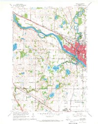
 1967 Osseo1969 Print · USGSHennepin County suburbs were rapidly transforming in the late sixties as residential developments met industrial expansion. Researchers can trace family sites and local landmarks like Gethsemane Cemetery, Mission Farms, and North Hennepin State College.5 unique versions available
 - 1967 Map of Anoka, 1969 Print
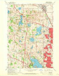
 1967 Anoka1969 Print · USGSAnoka and Champlin sit at a pivotal river junction in the late sixties as suburban growth begins to reach the surrounding prairies. Researchers can trace the layout of the State Hospital or find family plots at Oakwood Cem and Maple Grove Cem.4 unique versions available
End of results
Showing maps 1-3 of 3
Top cities near Maple Grove
- Minneapolis historical maps
- Brooklyn Park historical maps
- Plymouth historical maps
- Coon Rapids historical maps
- Eden Prairie historical maps
- Blaine historical maps
See more
Top neighborhoods of Maple Grove
- The Enclave at Dunlavin Woods historical maps
- The Village of Rush Creek historical maps
- Shadow Creek historical maps
- Creekside Estates historical maps
- Elm Creek Crossing historical maps
- Timber Bay Estates historical maps
See more
Frequently asked questions
- What are the different types of historical maps available for Maple Grove?
- What is the oldest map of Maple Grove?
- Where can I purchase historical maps of Maple Grove for my home or office?
- Where can I download high-res historical maps of Maple Grove?
- Are there historical topographic maps available for Maple Grove?
- Is there historical aerial imagery available for Maple Grove?
- Where are historical maps of Maple Grove sourced from?