2020s Maps of Village Terrace, Hokah
Explore 1 historic maps of Village Terrace from the 2020s. These maps offer a rare glimpse into what life looked like during the 2020s — showing old roads, neighborhoods, homes, and landmarks that have changed or disappeared over time.
Whether you're researching your family's past, planning a metal detecting trip, or studying how Village Terrace's landscape evolved across the 2020s, these high-resolution maps are a powerful tool for exploring the history of this region.
- Focus on a specific era: All maps on this page are from the 2020s, giving you a focused view of this time period.
- See what’s changed: Compare century-old streets, trails, and buildings to today's modern landscape using overlays and satellite layers.
- Research with precision: Use these maps for genealogy, historical research, land use analysis, or educational projects.
- View, download, or print: Maps are fully viewable online in high resolution, and can be downloaded or printed for your own records.
Start exploring Village Terrace's history through authentic maps from the 2020s. This is your window into the past.
Village Terrace, Hokah maps
(1)- 2022 Map of La Crescent, 2022 Print
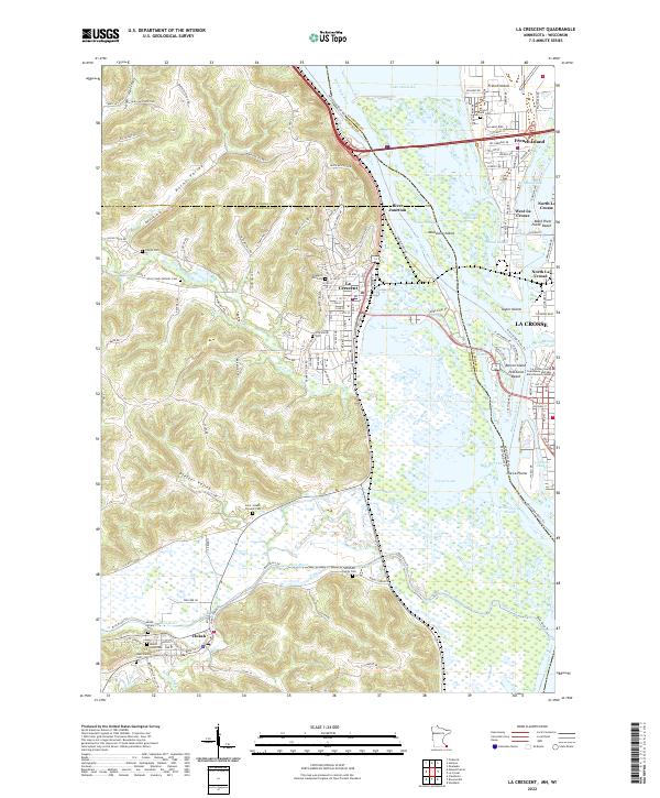 2022 La Crescent2022 Print · USGSThe riverfronts of Minnesota and Wisconsin meet here at the start of the 2020s, showing a landscape defined by braided waterways and bluff-side settlements. Researchers can locate numerous family and parish burial grounds, including the Hoffman Family Cem and Saint Joseph Convent Cem, alongside the industrial rail corridor of the CP Rail.
End of results
Showing maps 1-1 of 1
Top cities near Village Terrace
- La Crosse historical maps
- Onalaska historical maps
- Holmen historical maps
- West Salem historical maps
- La Crescent historical maps
- Shelby historical maps
See more
Frequently asked questions
- What are the different types of historical maps available for Village Terrace?
- What is the oldest map of Village Terrace?
- Where can I purchase historical maps of Village Terrace for my home or office?
- Where can I download high-res historical maps of Village Terrace?
- Are there historical topographic maps available for Village Terrace?
- Is there historical aerial imagery available for Village Terrace?
- Where are historical maps of Village Terrace sourced from?