1970s Maps of Laurel, Minnesota
Explore 2 historic maps of Laurel from the 1970s. These maps offer a rare glimpse into what life looked like during the 1970s — showing old roads, neighborhoods, homes, and landmarks that have changed or disappeared over time.
Whether you're researching your family's past, planning a metal detecting trip, or studying how Laurel's landscape evolved across the 1970s, these high-resolution maps are a powerful tool for exploring the history of this region.
- Focus on a specific era: All maps on this page are from the 1970s, giving you a focused view of this time period.
- See what’s changed: Compare century-old streets, trails, and buildings to today's modern landscape using overlays and satellite layers.
- Research with precision: Use these maps for genealogy, historical research, land use analysis, or educational projects.
- View, download, or print: Maps are fully viewable online in high resolution, and can be downloaded or printed for your own records.
Start exploring Laurel's history through authentic maps from the 1970s. This is your window into the past.
Laurel, MN maps
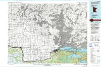
(2)- 1970 Map of Devlin, 1973 Print
 1970 Devlin1973 Print · USGSThe international border along the Rainy River comes to life in the early 1970s, showcasing the timberlands and rail lines of the northern frontier. Researchers can trace the Canadian National tracks through Devlin or explore the Old Railroad Grade in the Smokey Bear State Forest.
 - 1978 Map of International Falls, 1993 Print
 1978 International Falls1993 Print · USGSThe Minnesota-Ontario borderlands come alive in the late seventies, where the timber and rail economy meets the lake wilderness. Genealogists and local historians can trace the growth of International Falls and Ranier or locate island landmarks like Grindstone Island and Bushyhead Island.
End of results
Showing maps 1-2 of 2
Top cities near Laurel
Frequently asked questions
- What are the different types of historical maps available for Laurel?
- What is the oldest map of Laurel?
- Where can I purchase historical maps of Laurel for my home or office?
- Where can I download high-res historical maps of Laurel?
- Are there historical topographic maps available for Laurel?
- Is there historical aerial imagery available for Laurel?
- Where are historical maps of Laurel sourced from?