1980s Maps of Lake No. 1, Minnesota
Explore 4 historic maps of Lake No. 1 from the 1980s. These maps offer a rare glimpse into what life looked like during the 1980s — showing old roads, neighborhoods, homes, and landmarks that have changed or disappeared over time.
Whether you're researching your family's past, planning a metal detecting trip, or studying how Lake No. 1's landscape evolved across the 1980s, these high-resolution maps are a powerful tool for exploring the history of this region.
- Focus on a specific era: All maps on this page are from the 1980s, giving you a focused view of this time period.
- See what’s changed: Compare century-old streets, trails, and buildings to today's modern landscape using overlays and satellite layers.
- Research with precision: Use these maps for genealogy, historical research, land use analysis, or educational projects.
- View, download, or print: Maps are fully viewable online in high resolution, and can be downloaded or printed for your own records.
Start exploring Lake No. 1's history through authentic maps from the 1980s. This is your window into the past.
Lake No. 1, MN maps
(4)- 1981 Map of Silver Island Lake, 1982 Print
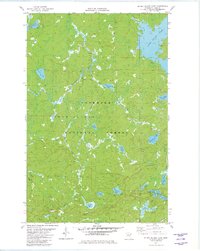 1981 Silver Island Lake1982 Print · USGSLake County, Minnesota, in the early eighties was a landscape of dense timber and quiet glacial waters within the Superior National Forest. Trace the waterways of the Dumbbell River and find isolated points like Homestead Lake and the Winter Trail.2 unique versions available
 - 1981 Map of Cramer, 1982 Print
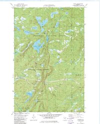 1981 Cramer1982 Print · USGSThe Sawtooth Mountains of Lake County are captured here in the early 1980s, showing a rugged landscape shaped by forestry and transit. Local historians can trace the Mining Railroad near Cramer or locate the old grades around Pearl Lake and Hare Lake.2 unique versions available
 - 1981 Map of Wilson Lake, 1982 Print
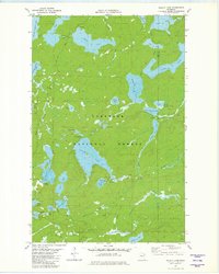 1981 Wilson Lake1982 Print · USGSLake County and Cook County meet in this northern forest during the early eighties, where a dense network of glacial lakes and river systems defines the landscape. Historians and outdoor enthusiasts can trace the Old Railroad Grade and find remote water bodies like Elbow Lake and Dam Five Lake.2 unique versions available
 - 1982 Map of Cabin Lake
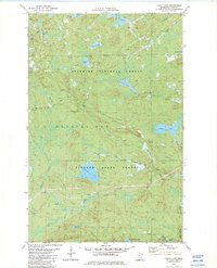 1982 Cabin Lake1982 Print · USGSLake County's dense forests and river valleys are captured here in the early eighties, highlighting the intersection of state and national lands. Researchers can locate the Cramer Homestead and trace the paths of the Old Railroad Grade and General Grade Road.2 unique versions available
End of results
Showing maps 1-4 of 4
Top cities near Lake No. 1
Top neighborhoods of Lake No. 1
- Little Marais Postoffice historical maps
- Little Marais historical maps
- Cramer historical maps
- Bell Harbor historical maps
- Kennedy Landing historical maps
Frequently asked questions
- What are the different types of historical maps available for Lake No. 1?
- What is the oldest map of Lake No. 1?
- Where can I purchase historical maps of Lake No. 1 for my home or office?
- Where can I download high-res historical maps of Lake No. 1?
- Are there historical topographic maps available for Lake No. 1?
- Is there historical aerial imagery available for Lake No. 1?
- Where are historical maps of Lake No. 1 sourced from?