1960s Maps of Le Sueur County, Minnesota
Explore 12 historic maps of Le Sueur County from the 1960s. These maps offer a rare glimpse into what life looked like during the 1960s — showing old roads, neighborhoods, homes, and landmarks that have changed or disappeared over time.
Whether you're researching your family's past, planning a metal detecting trip, or studying how Le Sueur County's landscape evolved across the 1960s, these high-resolution maps are a powerful tool for exploring the history of this region.
- Focus on a specific era: All maps on this page are from the 1960s, giving you a focused view of this time period.
- See what’s changed: Compare century-old streets, trails, and buildings to today's modern landscape using overlays and satellite layers.
- Research with precision: Use these maps for genealogy, historical research, land use analysis, or educational projects.
- View, download, or print: Maps are fully viewable online in high resolution, and can be downloaded or printed for your own records.
Start exploring Le Sueur County's history through authentic maps from the 1960s. This is your window into the past.
Le Sueur County, MN maps
(12)- 1965 Map of Cleveland, 1966 Print
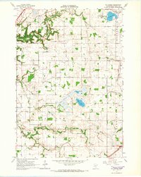
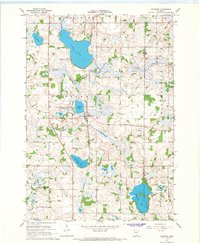
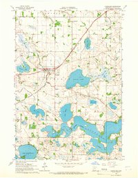 1965 Cleveland1966 Print · USGSCleveland and the surrounding lake country of Le Sueur County are captured here in the mid-1960s as agricultural drainage reshaped the landscape. Family historians can locate several local burial sites including Calvary Cem and Cleveland Cem, or trace the path of the Chicago Milwaukee St Paul and Pacific rail line.2 unique versions available
 - 1965 Map of North Star, 1966 Print
 1965 North Star1966 Print · USGSNicollet County’s agricultural heartland and the Minnesota River bluffs are captured here in the mid-sixties. Local historians can trace early routes like the Old Fort Road and locate rural landmarks such as St Michael Ch and the settlement of Oshawa.2 unique versions available
 - 1965 Map of St Peter, 1966 Print
 1965 St Peter1966 Print · USGSThe Minnesota River valley comes into sharp focus during the mid-sixties, capturing the institutional and industrial heart of St. Peter and Kasota. Researchers can trace the grounds of Gustavus Adolphus College, the Milwaukee Road rail lines, and local landmarks like Elim Welsh Cem.3 unique versions available
 - 1965 Map of Le Sueur, 1966 Print
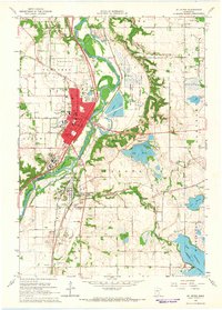
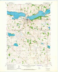
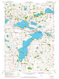
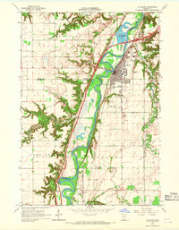 1965 Le Sueur1966 Print · USGSLe Sueur and the Minnesota River valley are captured in the mid-sixties during a period of steady growth and industrial activity. Researchers can trace the Chicago and North Western rail line and locate ancestral sites like Mound Cem and the settlement of Ottawa.4 unique versions available
 - 1965 Map of St Thomas, 1966 Print
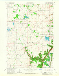
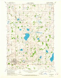
 1965 St Thomas1966 Print · USGSLe Sueur County in the mid-1960s reveals a deeply settled agricultural landscape shaped by its early townships and prairie lakes. Genealogists and local historians can locate numerous family burial sites like Dresselville Cem and Hillside Cem, or trace the old rail corridor of the Chicago Milwaukee St Paul and Pacific.2 unique versions available
 - 1966 Map of Montgomery, 1967 Print
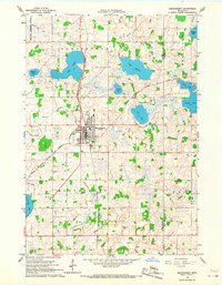 1966 Montgomery1967 Print · USGSLe Sueur and Rice counties are captured here in the mid-sixties, centered on the rail hub of Montgomery. Genealogists and local historians can trace family roots through numerous sites like Bohemian Cem, St Michael Cem, and the old High School.2 unique versions available
 - 1966 Map of Waterville, 1968 Print
 1966 Waterville1968 Print · USGSWaterville sits at the center of this mid-century survey, where the railroads and the Cannon River system define the local economy. Genealogists can trace rural roots through family-named landmarks like McPete Point and several old graveyards including Iosco Cem and Ebenezer Cem.2 unique versions available
 - 1966 Map of Cordova, 1968 Print
 1966 Cordova1968 Print · USGSLe Sueur County was a landscape of glacial lakes and managed wildlife areas in the mid-sixties. Genealogists and researchers can trace family landmarks like St Peters Ch, Gorman Cem, and the old settlement of Cordova.2 unique versions available
 - 1966 Map of Elysian, 1968 Print
 1966 Elysian1968 Print · USGSThe lakeside communities and rail corridors of south-central Minnesota are captured here in the mid-1960s, showing a landscape shaped by water and the Chicago Great Western railroad. Local historians can trace the early layout of Elysian and Greenland, find family landmarks like Sextons Point, or locate the Cedar Hill Cemetery.2 unique versions available
 - 1966 Map of Le Center, 1968 Print
 1966 Le Center1968 Print · USGSThe township boundaries of southern Minnesota meet here during the mid-sixties, centered on the hub of Le Center. Genealogists and local historians can trace the sites of Yankee Cem, St John Ch, and the winding Milwaukee Road railroad line.2 unique versions available
 - 1966 Map of Kilkenny, 1968 Print
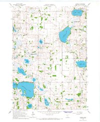
 1966 Kilkenny1968 Print · USGSThe lake-dotted landscape of Le Sueur County is captured here in the mid-1960s, centered on the railroad town of Kilkenny. Researchers can trace old family lines near Calvary Cem and locate historic hamlets like Doyle and Rogers along the rail line.2 unique versions available
 - 1967 Map of New Ulm
 1967 New Ulm1967 Print · USGSSouthern Minnesota in the mid-fifties is captured here as a landscape of river-valley missions and busy prairie rail towns. Researchers can trace the Yellow Medicine Trail and locate historic sites like the Morton Indian Mission and Milford State Monument.
End of results
Showing maps 1-12 of 12
Top cities of Le Sueur County
- Le Sueur historical maps
- Montgomery historical maps
- Le Center historical maps
- Waterville historical maps
- Lexington historical maps
- Cleveland historical maps
See more
Frequently asked questions
- What are the different types of historical maps available for Le Sueur County?
- What is the oldest map of Le Sueur County?
- Where can I purchase historical maps of Le Sueur County for my home or office?
- Where can I download high-res historical maps of Le Sueur County?
- Are there historical topographic maps available for Le Sueur County?
- Is there historical aerial imagery available for Le Sueur County?
- Where are historical maps of Le Sueur County sourced from?