1990s Maps of Le Sueur County, Minnesota
Explore 2 historic maps of Le Sueur County from the 1990s. These maps offer a rare glimpse into what life looked like during the 1990s — showing old roads, neighborhoods, homes, and landmarks that have changed or disappeared over time.
Whether you're researching your family's past, planning a metal detecting trip, or studying how Le Sueur County's landscape evolved across the 1990s, these high-resolution maps are a powerful tool for exploring the history of this region.
- Focus on a specific era: All maps on this page are from the 1990s, giving you a focused view of this time period.
- See what’s changed: Compare century-old streets, trails, and buildings to today's modern landscape using overlays and satellite layers.
- Research with precision: Use these maps for genealogy, historical research, land use analysis, or educational projects.
- View, download, or print: Maps are fully viewable online in high resolution, and can be downloaded or printed for your own records.
Start exploring Le Sueur County's history through authentic maps from the 1990s. This is your window into the past.
Le Sueur County, MN maps
(2)- 1991 Map of New Ulm
 1991 New Ulm1991 Print · USGSThe Minnesota River valley serves as the backbone for this late-century look at the agricultural heartland between New Ulm and Mankato. Researchers can trace the layout of traditional prairie towns like Sleepy Eye and Madelia or explore recreation sites at Fort Ridgely State Park.
 - 1991 Map of St Peter, 1995 Print
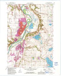 1991 St Peter1995 Print · USGSSt Peter and the Minnesota River valley are shown here in the early nineties, capturing the city's growth alongside its deep historical roots. Genealogists and researchers can trace local family history through Elim Welsh Cem and Kasota Cem or locate the old quarries that built the region's economy.2 unique versions available
End of results
Showing maps 1-2 of 2
Top cities of Le Sueur County
- Le Sueur historical maps
- Montgomery historical maps
- Le Center historical maps
- Waterville historical maps
- Lexington historical maps
- Cleveland historical maps
See more
Frequently asked questions
- What are the different types of historical maps available for Le Sueur County?
- What is the oldest map of Le Sueur County?
- Where can I purchase historical maps of Le Sueur County for my home or office?
- Where can I download high-res historical maps of Le Sueur County?
- Are there historical topographic maps available for Le Sueur County?
- Is there historical aerial imagery available for Le Sueur County?
- Where are historical maps of Le Sueur County sourced from?