1980s Maps of Lyon County, Minnesota
Explore 4 historic maps of Lyon County from the 1980s. These maps offer a rare glimpse into what life looked like during the 1980s — showing old roads, neighborhoods, homes, and landmarks that have changed or disappeared over time.
Whether you're researching your family's past, planning a metal detecting trip, or studying how Lyon County's landscape evolved across the 1980s, these high-resolution maps are a powerful tool for exploring the history of this region.
- Focus on a specific era: All maps on this page are from the 1980s, giving you a focused view of this time period.
- See what’s changed: Compare century-old streets, trails, and buildings to today's modern landscape using overlays and satellite layers.
- Research with precision: Use these maps for genealogy, historical research, land use analysis, or educational projects.
- View, download, or print: Maps are fully viewable online in high resolution, and can be downloaded or printed for your own records.
Start exploring Lyon County's history through authentic maps from the 1980s. This is your window into the past.
Lyon County, MN maps
(4)- 1985 Map of Brookings
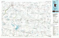
 1985 Brookings1985 Print · USGSThe South Dakota and Minnesota borderlands in the mid-1980s are defined here by a network of prairie lakes and bustling rail corridors. Researchers can trace the path of the Chicago and North Western through Brookings or explore the numerous wetlands of Oakwood Lakes State Park.2 unique versions available
 - 1985 Map of Clear Lake
 1985 Clear Lake1985 Print · USGSThe South Dakota and Minnesota borderlands are captured here in the mid-eighties as a landscape of prairie towns and wildlife refuges. Researchers can trace the legacy of regional transport through the Chicago and North Western tracks and the Old Railroad Grade.2 unique versions available
 - 1986 Map of Tracy
 1986 Tracy1986 Print · USGSSouthwestern Minnesota's prairie rail towns and conservation lands are captured here in the mid-1980s. Researchers can trace the Chicago and North Western line through Walnut Grove or explore the many lakebeds and wildlife areas like Lake Sarah and Lake Shetek State Park.2 unique versions available
 - 1986 Map of Montevideo
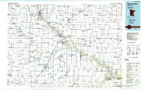 1986 Montevideo1986 Print · USGSWestern Minnesota’s river valleys and prairie townships are captured here in the mid-eighties, showing the region's agricultural and rail network. Trace family roots and local history through Montevideo, Granite Falls, and the Upper Sioux Agency State Park.2 unique versions available
End of results
Showing maps 1-4 of 4
Top cities of Lyon County
- Marshall historical maps
- Tracy historical maps
- Minneota historical maps
- Cottonwood historical maps
- Balaton historical maps
- Lynd historical maps
See more
Frequently asked questions
- What are the different types of historical maps available for Lyon County?
- What is the oldest map of Lyon County?
- Where can I purchase historical maps of Lyon County for my home or office?
- Where can I download high-res historical maps of Lyon County?
- Are there historical topographic maps available for Lyon County?
- Is there historical aerial imagery available for Lyon County?
- Where are historical maps of Lyon County sourced from?