1980s Maps of March, Minnesota
Explore 2 historic maps of March from the 1980s. These maps offer a rare glimpse into what life looked like during the 1980s — showing old roads, neighborhoods, homes, and landmarks that have changed or disappeared over time.
Whether you're researching your family's past, planning a metal detecting trip, or studying how March's landscape evolved across the 1980s, these high-resolution maps are a powerful tool for exploring the history of this region.
- Focus on a specific era: All maps on this page are from the 1980s, giving you a focused view of this time period.
- See what’s changed: Compare century-old streets, trails, and buildings to today's modern landscape using overlays and satellite layers.
- Research with precision: Use these maps for genealogy, historical research, land use analysis, or educational projects.
- View, download, or print: Maps are fully viewable online in high resolution, and can be downloaded or printed for your own records.
Start exploring March's history through authentic maps from the 1980s. This is your window into the past.
March, MN maps
(2)- 1982 Map of Alvarado
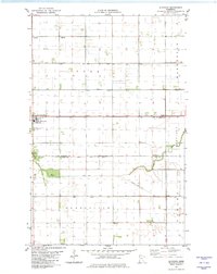 1982 Alvarado1982 Print · USGSAlvarado and its surrounding townships in the Red River Valley are documented here in the early eighties. Local researchers can trace the Soo Line railroad and locate family landmarks like Oak Lawn Cem, Vega Cem, and the Townhall in Sandsville.
 - 1985 Map of Thief River Falls
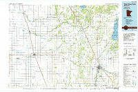 1985 Thief River Falls1985 Print · USGSNorthwestern Minnesota’s agricultural heartland is captured here in the mid-eighties, showing the transition from drainage-dependent farmlands to vast wildlife refuges. Trace the Burlington Northern rail lines through Warren and Stephen, or locate family landmarks near Dakota Junction and Carpenters Corner.
End of results
Showing maps 1-2 of 2
Top cities near March
- Warren historical maps
- Argyle historical maps
- Alvarado historical maps
- Tabor historical maps
- Angus historical maps
- Big Woods historical maps
Frequently asked questions
- What are the different types of historical maps available for March?
- What is the oldest map of March?
- Where can I purchase historical maps of March for my home or office?
- Where can I download high-res historical maps of March?
- Are there historical topographic maps available for March?
- Is there historical aerial imagery available for March?
- Where are historical maps of March sourced from?