1980s Maps of South Silver Lake, Rich Valley Township
Explore 2 historic maps of South Silver Lake from the 1980s. These maps offer a rare glimpse into what life looked like during the 1980s — showing old roads, neighborhoods, homes, and landmarks that have changed or disappeared over time.
Whether you're researching your family's past, planning a metal detecting trip, or studying how South Silver Lake's landscape evolved across the 1980s, these high-resolution maps are a powerful tool for exploring the history of this region.
- Focus on a specific era: All maps on this page are from the 1980s, giving you a focused view of this time period.
- See what’s changed: Compare century-old streets, trails, and buildings to today's modern landscape using overlays and satellite layers.
- Research with precision: Use these maps for genealogy, historical research, land use analysis, or educational projects.
- View, download, or print: Maps are fully viewable online in high resolution, and can be downloaded or printed for your own records.
Start exploring South Silver Lake's history through authentic maps from the 1980s. This is your window into the past.
South Silver Lake, Rich Valley Township maps
(2)- 1982 Map of Silver Lake
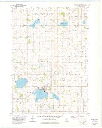 1982 Silver Lake1982 Print · USGSSilver Lake and the surrounding McLeod County townships are captured in the early eighties as a landscape of productive farms and glacial waters. Researchers can trace family history at Bohemian Cem or locate old community hubs like Henrys Corner and Sherman.
 - 1986 Map of Glencoe
 1986 Glencoe1986 Print · USGSThe south-central Minnesota prairie and its glacial lake basins are captured here in the mid-1980s, showcasing a landscape of intensive farming and conservation. Genealogists can locate family-named landmarks and trace the rail lines of the Soo Line and Chicago and North Western through towns like Gaylord, Olivia, and Hutchinson.2 unique versions available
End of results
Showing maps 1-2 of 2
Top cities near South Silver Lake
- Hutchinson historical maps
- Glencoe historical maps
- Cokato historical maps
- Winsted historical maps
- Howard Lake historical maps
- Lester Prairie historical maps
See more
Frequently asked questions
- What are the different types of historical maps available for South Silver Lake?
- What is the oldest map of South Silver Lake?
- Where can I purchase historical maps of South Silver Lake for my home or office?
- Where can I download high-res historical maps of South Silver Lake?
- Are there historical topographic maps available for South Silver Lake?
- Is there historical aerial imagery available for South Silver Lake?
- Where are historical maps of South Silver Lake sourced from?