1900s (20th Century) Maps of Pennington County, Minnesota
Explore 52 historic maps of Pennington County from the 1900s (20th Century). These maps offer a rare glimpse into what life looked like during the 1900s — showing old roads, neighborhoods, homes, and landmarks that have changed or disappeared over time.
Whether you're researching your family's past, planning a metal detecting trip, or studying how Pennington County's landscape evolved across the 1900s, these high-resolution maps are a powerful tool for exploring the history of this region.
- Focus on a specific era: All maps on this page are from the 1900s, giving you a focused view of this time period.
- See what’s changed: Compare century-old streets, trails, and buildings to today's modern landscape using overlays and satellite layers.
- Research with precision: Use these maps for genealogy, historical research, land use analysis, or educational projects.
- View, download, or print: Maps are fully viewable online in high resolution, and can be downloaded or printed for your own records.
Start exploring Pennington County's history through authentic maps from the 1900s. This is your window into the past.
Pennington County, MN maps
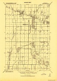
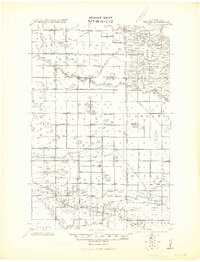
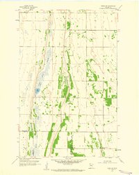
(52)- 1918 Map of Angus
 1918 Angus1918 Print · USGSThe Red River Valley's agricultural landscape is documented here during the Great War era, showing a region defined by rail lines and grain elevators. Family historians can trace rural property through schools and specific landmarks like the Lone Elevator and Cem. near Radium.
 - 1918 Map of Terrebonne
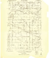
 1918 Terrebonne1918 Print · USGSNorthern Minnesota's river valleys and rail corridors are captured here just after the Great War. Genealogists and local historians can trace the early drainage systems and rail stops at Plummer, Terrebonne, and Brooks.2 unique versions available
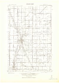
 - 1918 Map of Red Lake Falls
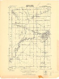 1918 Red Lake Falls1918 Print · USGSRed Lake County and eastern Polk County are captured here during the first World War as the regional rail network neared its peak. Researchers can trace the early footprints of Red Lake Falls, the winding Red Lake River, and smaller stops like Huot and Gentilly.
 - 1918 Map of Viking, 1943 Print
 1918 Viking1943 Print · USGSNorthwestern Minnesota at the end of the Great War is captured here as a grid of drainage ditches and emerging rail towns. Genealogists can locate family landmarks including the Cem. near Rosewood, the settlement of Bray, and more than a dozen rural schools.
 - 1919 Map of Grit
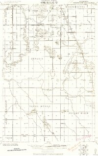
 1919 Grit1919 Print · USGSRed Lake and Polk counties are shown here at the close of the Great War, as drainage projects reshaped the marshy landscape. Genealogists can trace family roots through small settlements like Oklee, Brooks Station, and Lambert, or locate rural School sites and the Old Red Lake Indian Reservation Boundary Line.
 - 1919 Map of Winsor
 1919 Winsor1919 Print · USGSNorthern Minnesota's prairie and marshland appear here just after the Great War, during a period of massive drainage and rail expansion. Researchers can trace early rural life through labels for Winsor, the Red Lake Indian Reservation Trail, and the Minneapolis St. Paul and Sault Saint Marie railroad.2 unique versions available
 - 1943 Map of Thief River Falls
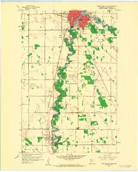
 1943 Thief River Falls1943 Print · USGSPennington County during the Second World War shows a landscape defined by the convergence of major rail lines and the drainage of the Red River Valley. Genealogists and historians can trace rail stops and rural landmarks like Steiner, St. Hilaire, and Church Cem.
 - 1952 Map of Red Lake Falls, 1954 Print
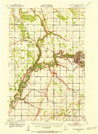 1952 Red Lake Falls1954 Print · USGSRed Lake Falls and the surrounding fertile prairies are shown here in the early fifties, just as the local rail-and-river economy was shifting. Genealogists can trace family footprints through numerous rural landmarks like Evangelical Ch, Marcoux Corners, and the Prairie Queen Sch.
 - 1952 Map of Grand Forks, 1967 Print
 1952 Grand Forks1967 Print · USGSThe Red River Valley in the early fifties is shown here at the height of its rail-and-river agricultural economy. Researchers can locate small-town landmarks like the Pleasant View School, the Immanuel Lutheran Church, and trace the path of the Soo Line Railroad.3 unique versions available
 - 1952 Map of Thief River Falls, 1967 Print
 1952 Thief River Falls1967 Print · USGSThe Red River Valley's agricultural and conservation landscape is captured in the mid-1950s, detailing a web of rail lines and international border crossings. Researchers can trace family roots in towns like Thief River Falls, locate the State School for Blind, and survey landmarks like the Agassiz National Wildlife Refuge.2 unique versions available
 - 1954 Map of Bemidji, 1966 Print
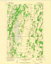
 1954 Bemidji1966 Print · USGSNorthern Minnesota's lake country and timberlands are captured here at a mid-century peak of rail and road expansion. Genealogists and historians can trace family roots through numerous small settlements like Mahnomen, Clearbrook, and Walker, while locating local landmarks such as White Earth Church.4 unique versions available
 - 1954 Map of Roseau, 1969 Print
 1954 Roseau1969 Print · USGSNorthern Minnesota's borderlands come alive in the 1950s, showing a landscape defined by timber, water, and rail. Trace family roots through old schools and cemeteries near Roseau, Warroad, and the expansive Red Lake Indian Reservation.2 unique versions available
 - 1956 Map of Thief River Falls
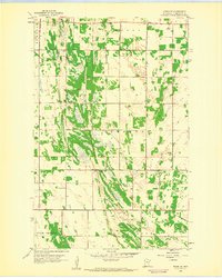
 1956 Thief River Falls1956 Print · USGSThe Red River Valley in the mid-1950s is captured here as a sprawling network of rail corridors and wildlife refuges along the Canadian border. Trace the vanished transport routes of the Dismantled railroad and Abandoned railroad or locate local landmarks like the Herrick Elevator and State School for Blind.
 - 1956 Map of Grand Forks
 1956 Grand Forks1956 Print · USGSThe Red River Valley in the mid-fifties is captured here as a thriving corridor of grain elevators and rail-linked towns along the North Dakota and Minnesota border. Researchers can trace historic church sites like Immanuel Lutheran Church, vanished rail stops at Tilde Junction, and the boundaries of the White Earth Indian Reservation.
 - 1957 Map of Roseau
 1957 Roseau1957 Print · USGSThe international border and tribal lands define Northern Minnesota in the mid-fifties, from the shores of Lake of the Woods to the Red Lake Indian Reservation. Researchers can trace the path of the Great Northern railroad and locate isolated outposts like the U S Custom House and Ponemah.
 - 1957 Map of Bemidji
 1957 Bemidji1957 Print · USGSNorthern Minnesota in the mid-fifties is defined by its massive lake systems and the sprawling timberlands of the Chippewa National Forest. Genealogists and researchers can trace old rail lines like the Great Northern RR and locate settlements such as Moberg, Naytahwaush, and Lake Itasca.
 - 1957 Map of Thief River Falls
 1957 Thief River Falls1957 Print · USGSThe Red River Valley in the mid-fifties is captured here as a thriving network of rail towns and conservation lands. Genealogists and historians can trace family roots through settlements like Grafton, Pembina, and Hallock, or locate landmarks such as the State School for Blind and the Great Northern RR corridor.
 - 1958 Map of Bemidji
 1958 Bemidji1958 Print · USGSNorthern Minnesota in the late fifties is a vast landscape of tribal lands and timber forests tied together by rail. Genealogists and researchers can trace old rail stops and lakeside communities from Walker to Fosston, or explore the source of the Mississippi at Lake Itasca.
 - 1958 Map of Roseau
 1958 Roseau1958 Print · USGSNorthern Minnesota's borderlands and vast lake country are captured here in the late fifties. Researchers can trace the Canadian National rail line through Warroad or find family history in frontier settlements like Baudette, Waskish, and Shotley.
 - 1959 Map of Viking, 1960 Print
 1959 Viking1960 Print · USGSNorthwestern Minnesota's prairie and river land is captured here in the late fifties as the regional rail economy remained vital. Genealogists and local historians can trace family land near Viking, Carpenters Corner, and the Roosevelt Sch.2 unique versions available
 - 1959 Map of Rosewood, 1960 Print
 1959 Rosewood1960 Print · USGSThe Marshall and Pennington County line in the late fifties shows a rural landscape anchored by the Soo Line railroad. Genealogy researchers can locate family sites at Wildwood Cem, Hegland Cem, and Rindal Ch.2 unique versions available
 - 1959 Map of Viking SW, 1960 Print
 1959 Viking SW1960 Print · USGSThe Pennington and Polk county line comes into focus in the late fifties, where the expanse of Goose Lake Swamp meets the prairie. Genealogists and local historians can trace the community's footprint through sites like Black River Ch, School No 1560, and the local Town Hall.
 - 1959 Map of Thief River Falls, 1960 Print
 1959 Thief River Falls1960 Print · USGSThief River Falls and St. Hilaire are captured at a mid-century crossroads where the Red Lake River meets heavy rail commerce. Researchers can trace family roots through numerous burial sites like Riverside Cem and landmarks such as Lincoln High Sch.2 unique versions available
 - 1959 Map of Viking SE, 1960 Print
 1959 Viking SE1960 Print · USGSPennington County's rural townships are preserved here in the late fifties, showcasing a landscape of section-line roads and family farmsteads. Genealogists can trace local history through the Norden Ch, Lafstad Cem, and two separate Town Hall locations.
 - 1961 Map of Radium, 1963 Print
 1961 Radium1963 Print · USGSMarshall County's prairie landscape in the early sixties is defined by remote townships and the essential route of the SOO LINE railroad. Family historians can trace local roots at Immanuel Cem and the Townhall near the winding Snake River.2 unique versions available
Showing maps 1-25 of 52
Top cities of Pennington County
Frequently asked questions
- What are the different types of historical maps available for Pennington County?
- What is the oldest map of Pennington County?
- Where can I purchase historical maps of Pennington County for my home or office?
- Where can I download high-res historical maps of Pennington County?
- Are there historical topographic maps available for Pennington County?
- Is there historical aerial imagery available for Pennington County?
- Where are historical maps of Pennington County sourced from?