1970s Maps of Pennington County, Minnesota
Explore 13 historic maps of Pennington County from the 1970s. These maps offer a rare glimpse into what life looked like during the 1970s — showing old roads, neighborhoods, homes, and landmarks that have changed or disappeared over time.
Whether you're researching your family's past, planning a metal detecting trip, or studying how Pennington County's landscape evolved across the 1970s, these high-resolution maps are a powerful tool for exploring the history of this region.
- Focus on a specific era: All maps on this page are from the 1970s, giving you a focused view of this time period.
- See what’s changed: Compare century-old streets, trails, and buildings to today's modern landscape using overlays and satellite layers.
- Research with precision: Use these maps for genealogy, historical research, land use analysis, or educational projects.
- View, download, or print: Maps are fully viewable online in high resolution, and can be downloaded or printed for your own records.
Start exploring Pennington County's history through authentic maps from the 1970s. This is your window into the past.
Pennington County, MN maps
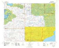
(13)- 1971 Map of Roland, 1976 Print
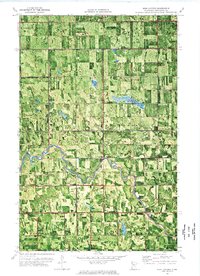
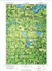
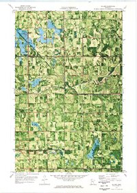 1971 Roland1976 Print · USGSRed Lake and Pennington counties are captured here in the early seventies, showing a landscape defined by the winding Clearwater River and local farmsteads. Genealogists can trace family footprints near Salem Ch, the small settlement of Roland, or the local Townhall.
 - 1972 Map of Erie, 1976 Print
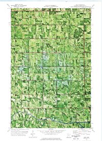 1972 Erie1976 Print · USGSPennington County's drainage networks and riverside townships are captured here in the early 1970s. Researchers can locate community landmarks like Reiner Ch, the Townhall, and the winding course of the Red Lake River.
 - 1972 Map of Goodridge SW, 1976 Print
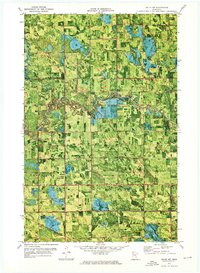
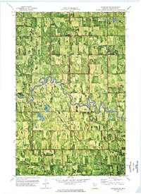 1972 Goodridge SW1976 Print · USGSPennington County’s agricultural landscape was reaching its modern maturity in the early seventies, defined by the winding Red Lake River. Genealogists and local historians can locate the Telemarken Ch (Cem) and trace the extensive network of drainage projects like County Ditch No 32.
 - 1972 Map of Goodridge, 1976 Print
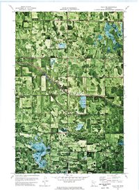
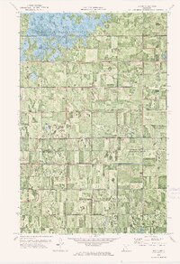
 1972 Goodridge1976 Print · USGSIn the early 1970s, this area of Pennington County reveals a landscape defined by prairie drainage and early transit. Researchers can trace the Old Indian Treaty Bdy and an Old Railroad Grade near Goodridge.
 - 1972 Map of Good Lake, 1976 Print
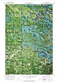
 1972 Good Lake1976 Print · USGSThe marshy borders of Beltrami, Pennington, and Clearwater counties are captured in the early 1970s, showcasing a landscape of seasonal routes and tribal boundaries. Researchers can trace the Red Lake Indian Reservation Boundary, the remote Little Oak Cem, and the path of the Winter Trail.
 - 1972 Map of Gully NW, 1976 Print
 1972 Gully NW1976 Print · USGSPennington County and its neighbors are seen here in the early 1970s, showing a landscape shaped by drainage ditches and timbered parklands. Local historians can locate the Bethany Ch, the community Townhall, and the engineered paths of Judicial Ditch No 3.
 - 1972 Map of High Landing, 1976 Print
 1972 High Landing1976 Print · USGSPennington County's agricultural heartland is documented here in the early seventies, centered on the winding Red Lake River. Researchers can trace local landmarks like High Landing, the Oak Park Ch, and the extensive network of drainage ditches including County Ditch No 41.
 - 1972 Map of Gully NE, 1976 Print
 1972 Gully NE1976 Print · USGSThe northern river country of Clearwater and Polk Counties is captured here in the early seventies, where the Red Lake River meets the reservation boundary. Researchers can trace land use near Hickory or locate the Gully State Wildlife Management Area and local Gravel Pit.
 - 1972 Map of Oklee NW, 1976 Print
 1972 Oklee NW1976 Print · USGSRed Lake and Pennington counties are shown in the early 1970s as agricultural drainage projects and the Soo Line railroad defined the rural landscape. Local historians can trace the Indian Reservation Boundary and locate landmarks like the Finnish Cem and Ebenezer Ch.
 - 1973 Map of Erie NE, 1976 Print
 1973 Erie NE1976 Print · USGSIn the early 1970s, the northern Minnesota wilderness remained a complex landscape of wetlands and treaty lands. Researchers can trace the Old Indian Treaty Boundary and the borders of the Red Lake Indian Reservation alongside the Carmel State Wildlife Management Area.
 - 1973 Map of Mavie, 1976 Print
 1973 Mavie1976 Print · USGSNorthwestern Minnesota agricultural lands are shown in the early 1970s, defined by a complex grid of drainage ditches and prairie. Researchers can trace local history through the Old Railroad Grade and the Germantown Cem near Mavie.
 - 1973 Map of Erie NW, 1976 Print
 1973 Erie NW1976 Print · USGSMarshall County's rural farming landscape is frozen in time during the early 1970s, showcasing the intersection of history and agriculture. Genealogists and local historians can trace the Old Indian Treaty Boundary and locate small landmarks like Jerusalem Cem and Rosindhall Ch.
 - 1977 Map of Grygla, 1978 Print
 1977 Grygla1978 Print · USGSNorthern Minnesota in the late seventies is a landscape of expansive state forests and managed wetlands. Genealogists and historians can trace the remote outposts of Malcolm, Four Town, and Erie or locate family landmarks near Randeen Ridge and Thief Lake.
End of results
Showing maps 1-13 of 13
Top cities of Pennington County
Frequently asked questions
- What are the different types of historical maps available for Pennington County?
- What is the oldest map of Pennington County?
- Where can I purchase historical maps of Pennington County for my home or office?
- Where can I download high-res historical maps of Pennington County?
- Are there historical topographic maps available for Pennington County?
- Is there historical aerial imagery available for Pennington County?
- Where are historical maps of Pennington County sourced from?