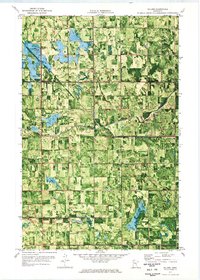
1971 Map of Roland
USGS Topo · Published 1976About this map
The Clearwater River meanders across this rural landscape in the early 1970s, defining a region where intensive water management and agricultural boundaries converge. The map illustrates a complex network of man-made waterways, including Judicial Ditch No 1 and Judicial Ditch No 58, which were critical for draining the low-lying prairie of northwestern Minnesota for cultivation. The southern portion of the sheet is marked by the Red Lake Indian Reservation Boundary, while the tiny settlement of Roland and the Salem Ch serve as local community hubs. This orthophotomap combines traditional topographic contours with aerial imagery, providing a rare look at the precise vegetation patterns and land use between the townships of Mayfield, Deer Park, Garnes, and Equality.
Find a feature on this map
15 named features on this map. Tap any name to fly to it.
Don’t see what you’re looking for? This feature index may not catch every label — zoom into the map to look around manually.
Map Details
Editions of this 1971 Roland Map
This is the sole edition of this map. No revisions or reprints were ever made.
Other maps of this area

1919 · Grit
USGS Topo · 1:62,500

1919 · Winsor
USGS Topo · 1:62,500

1954 · Bemidji
USGS Topo · 1:250,000

1954 · Roseau
USGS Topo · 1:250,000

1957 · Roseau
USGS Topo · 1:250,000

1957 · Bemidji
USGS Topo · 1:250,000

1958 · Bemidji
USGS Topo · 1:250,000

1958 · Roseau
USGS Topo · 1:250,000
1971 · Oklee
USGS Topo · 1:24,000
1971 · Oklee SW
USGS Topo · 1:24,000