1957 Map of Bemidji
USGS Topo · Published 1957About this map
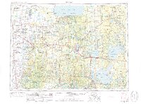
Lake Itasca serves as the geographic heart of this mid-century survey, marking the headwaters of the Mississippi River as it begins its long journey south. This territory is characterized by its massive water bodies and extensive tribal lands, including the Red Lake Indian Reservation to the north and the White Earth Indian Reservation to the west. The landscape is a complex network of glacial lakes and rivers, with the Chippewa National Forest blanketing the eastern portion of the map.
Find a feature on this map
122 named features on this map. Tap any name to fly to it.
Don’t see what you’re looking for? This feature index may not catch every label — zoom into the map to look around manually.
Map Details
Editions of this 1957 Bemidji Map
This is the sole edition of this map. No revisions or reprints were ever made.
Historical Maps of Bemidji Through Time
3 maps found