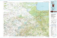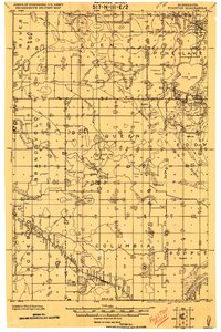
1919 Map of Fosston
USGS Topo · Published 1919About this map
Fosston and its surrounding townships emerge from the wetlands and timber of northwest Minnesota in this progressive military survey. The landscape is defined by an extensive drainage system, where labels like Ditch No 81 and Indian Ditch speak to the early 20th-century efforts to reclaim land for agriculture. Transport and trade are anchored by the Great Northern RR passing through Lengby in the south, while the Minneapolis St. Paul & S. St. Marie RR serves Gonvick to the northeast. Scattered settlements such as Weme, Popple, and Theodore highlight the rural community structure of the era, supported by numerous unnamed schools and churches. Prominent water bodies including Pine Lake, Whitefish Lake, and the Hill River are mapped alongside the Reservation Boundary, showing the intersection of natural geography and historical jurisdictional lines.
Find a feature on this map
57 named features on this map. Tap any name to fly to it.
Don’t see what you’re looking for? This feature index may not catch every label — zoom into the map to look around manually.
Map Details
Editions of this 1919 Fosston Map
This is the sole edition of this map. No revisions or reprints were ever made.