
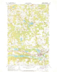
1969 Map of Ebro
USGS Topo · Published 1971About this map
The Burlington Northern corridor anchors this northern Minnesota landscape, passing through the small settlement of Ebro and bridging the neck of Long Lake. The survey reveals a region defined by complex aquatic geography, including the meandering Wild Rice River and Rice River, which flow through the southern timberlands of the White Earth State Forest. Cultural sites are concentrated near the northern rail line, where the Holiness Ch and Holiness Cem serve the local community.
Find a feature on this map
33 named features on this map. Tap any name to fly to it.
Don’t see what you’re looking for? This feature index may not catch every label — zoom into the map to look around manually.
Map Details
Editions of this 1969 Ebro Map
This is the sole edition of this map. No revisions or reprints were ever made.
Other maps of this area

1919 · Fosston
USGS Topo · 1:62,500

1943 · Bagley
USGS Topo · 1:62,500

1954 · Bemidji
USGS Topo · 1:250,000

1957 · Bemidji
USGS Topo · 1:250,000

1958 · Bemidji
USGS Topo · 1:250,000

1969 · North Twin Lake
USGS Topo · 1:24,000

1969 · Roy Lake
USGS Topo · 1:24,000

1969 · Fosston SE
USGS Topo · 1:24,000

1969 · Fosston East
USGS Topo · 1:24,000
1969 · Bagley
USGS Topo · 1:24,000