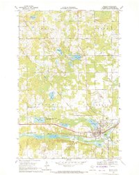
1969 Map of Bagley
USGS Topo · Published 1971About this map
Bagley serves as the focal point of this late-1960s survey, situated along the Burlington Northern railroad and the Clearwater River. The landscape is a complex network of glacial lakes and wetlands, including Hegre Lake, Willborg Lake, and Monson Lake, transitioning into the managed lands of the Clearwater State Wildlife Management Area. A notable historical demarcation, the Old Red Lake Indian Reservation Boundary, cuts diagonally through Popple and Eddy townships, reflecting earlier jurisdictional divisions of the region.
Find a feature on this map
43 named features on this map. Tap any name to fly to it.
Don’t see what you’re looking for? This feature index may not catch every label — zoom into the map to look around manually.
Map Details
Editions of this 1969 Bagley Map
This is the sole edition of this map. No revisions or reprints were ever made.
Other maps of this area

1919 · Fosston
USGS Topo · 1:62,500

1943 · Bagley
USGS Topo · 1:62,500

1954 · Bemidji
USGS Topo · 1:250,000

1957 · Bemidji
USGS Topo · 1:250,000

1958 · Bemidji
USGS Topo · 1:250,000

1969 · Ebro
USGS Topo · 1:24,000

1969 · Clearbrook
USGS Topo · 1:24,000

1969 · Leonard
USGS Topo · 1:24,000

1969 · Fosston SE
USGS Topo · 1:24,000

1969 · Gonvick
USGS Topo · 1:24,000