
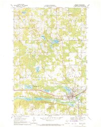
1969 Map of Leonard
USGS Topo · Published 1971About this map
Leonard sits at the intersection of local rail and water systems in Clearwater County, where the Soo Line railroad cuts through a landscape heavily defined by its glacial hydrology. The map reveals a pattern of rural community centers anchored by religious and memorial sites, such as Seljord Ch and the neighboring East Seljord Cem. Large portions of the terrain are dedicated to conservation, notably the Clearwater State Wildlife Management Area and the Old Red Lake Trail State Wildlife Management Area, preserving the wetlands surrounding the Clearwater River. Local industry is evidenced by numerous Gravel Pits and a Pipeline corridor. Distinctive water bodies like West Four Legged Lake and Stenlund Lake dominate the eastern half, while a Lookout Tower serves as a prominent navigational landmark for the region.
Find a feature on this map
39 named features on this map. Tap any name to fly to it.
Don’t see what you’re looking for? This feature index may not catch every label — zoom into the map to look around manually.
Map Details
Editions of this 1969 Leonard Map
This is the sole edition of this map. No revisions or reprints were ever made.
Other maps of this area

1919 · Solway
USGS Topo · 1:62,500

1919 · Churnes
USGS Topo · 1:62,500

1943 · Solway
USGS Topo · 1:62,500

1943 · Bagley
USGS Topo · 1:62,500

1954 · Bemidji
USGS Topo · 1:250,000

1957 · Bemidji
USGS Topo · 1:250,000

1958 · Bemidji
USGS Topo · 1:250,000

1969 · Clearbrook
USGS Topo · 1:24,000
1969 · Bagley
USGS Topo · 1:24,000

1969 · Shevlin
USGS Topo · 1:24,000