
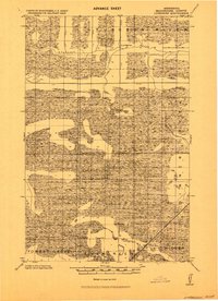
1919 Map of Lundgren
USGS Topo · Published 1919About this map
Lundgren and the surrounding Koochiching County wetlands are documented here in this 1919 progressive military map. The landscape is defined by the wandering Sturgeon River in the north and Dinner Creek to the east, set against a backdrop of drainage projects like the Jud. Ditch. The settlement pattern follows the Minnesota and International railroad line in the southeast corner, which served as the primary artery for the region's early 20th-century economy.
Find a feature on this map
11 named features on this map. Tap any name to fly to it.
Don’t see what you’re looking for? This feature index may not catch every label — zoom into the map to look around manually.
Map Details
Editions of this 1919 Lundgren Map
2 editions found
Other maps of this area

1918 · Zora
USGS Topo · 1:62,500

1919 · Zora
USGS Topo · 1:62,500

1919 · Gemmell
USGS Topo · 1:62,500

1919 · Norden
USGS Topo · 1:62,500

1919 · I
USGS Topo · 1:62,500

1919 · Bridgie
USGS Topo · 1:62,500

1919 · Margie
USGS Topo · 1:62,500

1924 · Bridgie
USGS Topo · 1:62,500

1943 · Lindford
USGS Topo · 1:62,500

1954 · Bemidji
USGS Topo · 1:250,000