
1918 Map of Flom
USGS Topo · Published 1918About this map
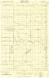
The South Branch Wild Rice River meanders across this rural landscape at the junction of Norman, Clay, Mahnomen, and Becker counties. Compiled by the Corps of Engineers, U.S. Army just before the end of the Great War, this survey documents a period of established township organization across Atlanta, Walworth, and Flom. The settlement pattern is defined by a dense network of country schoolhouses and churches, such as those near the Flom P.O. and the village of Fossum.
Find a feature on this map
30 named features on this map. Tap any name to fly to it.
Don’t see what you’re looking for? This feature index may not catch every label — zoom into the map to look around manually.
Map Details
Editions of this 1918 Flom Map
This is the sole edition of this map. No revisions or reprints were ever made.
Other maps of this area

1918 · Twin Valley
USGS Topo · 1:62,500
1918 · Ulen
USGS Topo · 1:62,500
1919 · Hawley
USGS Topo · 1:62,500

1952 · Grand Forks
USGS Topo · 1:250,000

1953 · Fargo
USGS Topo · 1:250,000

1953 · Brainerd
USGS Topo · 1:250,000

1954 · Bemidji
USGS Topo · 1:250,000

1956 · Fargo
USGS Topo · 1:250,000

1956 · Grand Forks
USGS Topo · 1:250,000

1957 · Brainerd
USGS Topo · 1:250,000